Free Downloads: Xls Dbf Gis
License: All | Free
AvisMap Gis Engine is the basic development platform for AvisMap Gis suites, which is a new generation component Gis development platform for Gis application developers. AvisMap Gis Engine 5 provides powerful Gis functions through Active X controls based on Microsoft COM component technique standards. It allows users to rapidly develop professional...
Category: Multimedia & Design / Multimedia App's
Publisher: AvisMap GIS Technologies, License: Freeware, Price: USD $0.00, File Size: 60.5 MB
Platform: Windows
 Freeware
DB Elephant Dbf Console is a handy tool for Dbf database management and development. Make your data management like editing, filtering, grouping or sorting clear and convenient. A handy Dbf editor is included. Create and execute queries in the most comfortable way. DB Elephant Dbf Console has a well-thought interface. It makes the tool good even for beginners -...
Category: Software Development / Databases & Networks
Publisher: DBElephant, License: Freeware, Price: USD $0.00, File Size: 2.3 MB
Platform: Windows
DIVA-GIS is a GIS for plant biodiversity analysis.
DIVA-Gis is a Gis for plant biodiversity analysis. The project will modernize the architecture for better collaboration and extensibility based on Eclipse RCP.
DIVA-Gis can be used to map and analyze biological distribution data, such as can be provided by natural history collections and genetic resources collections. Typically, the distribution data would refer to...
Category: Business & Finance / Business Finance
Publisher: International Potato Center (CIP), License: Freeware, Price: USD $0.00, File Size: 122.4 MB
Platform: Windows
SqlFileInfo is a freeware app to show and export data from MDB, XLS and DBF files.
SqlFileInfo is a freeware app to show and export data from MDB, Xls and Dbf files.
The data can be viewed on screen of exported as TXT (MDB2TXT , XLS2TXT, DBF2TXT), CSV (MDB2CSV , XLS2CSV, DBF2CSV) or XML (MDB2XML , XLS2XML, DBF2XML). The user can select the columns that will be in the export (file).
The data are selected with a SQL statement. This gives the freedom to...
Category: Audio / Utilities & Plug-Ins
Publisher: John Martens, License: Freeware, Price: USD $0.00, File Size: 1.9 MB
Platform: Windows
Freeware
Exportizer is a free database export tool. It allows to export data to file, clipboard, or printer. Exportizer works via BDE or ADO. It can convert DB, Dbf, text, CSV to text, CSV, Xls, RTF, XML, HTML, Dbf, INSERT statements. Many export options ensure full control over output. There is an ability to specify the source-to-target field mappings. Export operations can be...
Category: Business & Finance / Database Management
Publisher: Vitaliy Levchenko, License: Freeware, Price: USD $0.00, File Size: 1.3 MB
Platform: Windows
DIVA-Gis is a free computer program for mapping and geographic data analysis (a geographic information system (Gis). With DIVA-Gis you can make maps of the world, or of a very small area, using, for example, state boundaries, rivers, a satellite image, and the locations of sites where an animal species was observed.
Category: Business & Finance / Applications
Publisher: diva-gis, License: Freeware, Price: USD $0.00, File Size: 3.8 MB
Platform: Windows
Smart DBF Repair recovery damaged DBF databases without any external software.
Smart Dbf Repair recovery damaged Dbf databases without any external software. The application analyzes your corrupted Dbf files, carefully restoring all headers and data records. Unlike competitors, Smart Dbf Repair not only fix Dbf headers but repair data in records. The repair process is fast and fully automated, allowing restoring Dbf files quickly...
Category: Web Authoring / Web Design Utilities
Publisher: Smart DBF Repair, License: Freeware, Price: USD $0.00, File Size: 730.3 KB
Platform: Windows
The Quantum GIS Tethys repository contains a lot of software from OSGeo projects.
The Quantum Gis Tethys repository contains a lot of software from OSGeo projects. Quantum Gis Tethys and all dependencies are included, along with Python, GRASS, GDAL, etc. This is most suitable for people who want to be able to update dependencies from the Quantum Gis Tethys repository easily. The installer is able to install from internet or just download all needed...
Category: Multimedia & Design / Graphics Viewers
Publisher: QGIS Development Team, License: Freeware, Price: USD $0.00, File Size: 369.0 KB
Platform: Windows
Dbf Converters? Shell is a special program which helps you to study options and command line parameters of Dbf Converters from WhiteTown Software.It has a simple and clear interface.Dbf Converters' Shell is a special program which helps you to study optio
Category: Software Development / Misc. Programming
Publisher: whitetown.com, License: Freeware, Price: USD $0.00, File Size: 693.0 KB
Platform: Windows, Mac, 2K, 2K3, Vista
So that you can identify the Mapping & Gis product that best suits your needs, use this simple Product Comparison. There are four main product types that you can use to create a GPS data collection and maintenance system, or mobile Gis solution. Use the links below to select a product group, and compare the features of each product within that group.
Category: Internet / Communications
Publisher: Trimble Navigation Limited, License: Freeware, Price: USD $0.00, File Size: 2.7 MB
Platform: Windows
Paradox dBase reader is a versatile viewer for Dbf/DB files (Paradox, dBase, FoxBase, Foxpro, Visual Foxpro, Visual DBase,...) With Paradox dBase reader you can view, sort, print Dbf file and export the data from them to a variety of formats (TXT, CSV, Excel, HTML, XML, RTF) without using any packages and more. In addition, offers convenient user interface, flexible configuration...
Category: Business & Finance / Database Management
Publisher: sportamok inc., License: Freeware, Price: USD $0.00, File Size: 3.6 MB
Platform: Windows
AccuGlobe Desktop 2007,a standardized platform for delivering solutions to the global Gis community, offers even more of what you demand in a desktop Gis application. Combining user-friendly design with significantly increased functionality, AccuGlobe Desktop 2007 gives you greater freedom in analyzing spatial data. In addition to functioning as the core engine behind many...
Category: Multimedia & Design / Multimedia App's
Publisher: Digital Data Technologies, Inc., License: Freeware, Price: USD $0.00, File Size: 9.8 MB
Platform: Windows
Freeware
CZ-All2Xls is the award-winning, powerful batch Excel converter that converts many Database Spreadsheets File formats (XLSX, Xls, HTML, XML, MTH, CSV, TEXT, Dbf, Lotus 1-2-3 wk4/wk3/wk1, Access MDB, WKS, WQ1, SLK, DIF etc) to Microsoft 2007 Excel Workbook .XLSX or MS Excel Worksheet .Xls! CZ-All2Xls supports batch conversion, command line and folder watcher. Batch...
Category: Business & Finance / Spreadsheets
Publisher: ConvertZone Software co.,ltd., License: Freeware, Price: USD $0.00, File Size: 683.6 KB
Platform: Windows
GeoSurveillance is software that combines spatial statistical routines with some basic Geographic Information Systems (Gis) functions to carry out retrospective and prospective statistical tests for the detection of geographic clustering. In this software, the focus is primarily on the spatial statistical analysis. Consequently, full Gis functionality is not provided. Gis...
Category: Home & Education / Miscellaneous
Publisher: NCGIA, License: Freeware, Price: USD $0.00, File Size: 2.4 MB
Platform: Windows
Freeware
VSceneGIS Desktop. (Gis) Analysis, Computing and Editing. Customer Project Development, Analysis, Computing and Gis editing. VSceneGIS Desktop applies the concept of Tree and Graph Topology to implement the data model in a Gis. Validation, Editing and Topological Behavior Export and import of data sources: PostgreSQL / PostGIS, Oracle, MySQL, SQLite / SpatiaLite,...
Category: Home & Education / Science
Publisher: vscenegis.com, License: Freeware, Price: USD $0.00, File Size: 118.4 MB
Platform: Windows
Viewing and updating of files DBF.
Viewing and updating of files Dbf. Simply and conveniently, as in a conductor. The driver does not demand ??? and additional. Any coding of tables... Except for it is sorting on any field - the cascade filter on any data (analogue EXCEL) - selection on fields - a print data- export data in 14 formats- recovering the remoted lines in tables (recovering the lines remoted on tables)-...
Category: Software Development / Tools & Editors
Publisher: AMX, License: Freeware, Price: USD $0.00, File Size: 1.3 MB
Platform: Windows
ArcGIS Explorer is a free, downloadable Gis viewer that gives you an easy way to explore, visualize and share Gis information. ArcGIS Explorer adds value to any Gis because it helps you deliver your authoritative data to a broad audience.
The ArcGIS Explorer Desktop Current User setup is intended for users who do not have administrator access on their computers and...
Category: Desktop Enhancements / Shell & Desktop Managers
Publisher: Environmental Systems Research Institute, Inc., License: Freeware, Price: USD $0.00, File Size: 94.0 MB
Platform: Windows
Quantum Gis provides a continously growing number of capabilities provided by core functions and plugins. You can visualize, manage, edit, analyse data, and compose printable maps. QGIS is an official project of the Open Source Geospatial Foundation (OSGeo). It runs on Linux, Unix, Mac OSX, and Windows and supports numerous vector, raster, and database formats and functionalities.
Category: Home & Education / Miscellaneous
Publisher: qgis.org, License: Freeware, Price: USD $0.00, File Size: 92.2 MB
Platform: Windows
ArcGIS Explorer Desktop is a free Gis viewer that gives you an easy way to explore, visualize, and share Gis information. ArcGIS Explorer adds value to any Gis because it helps you deliver your authoritative data to a broad audience.
Easy and intuitive to use it's easy for anyone to begin working with ArcGIS Explorer, with its intuitive and easy to use...
Category: Home & Education / Miscellaneous
Publisher: Environmental Systems Research Institute, Inc., License: Freeware, Price: USD $0.00, File Size: 100.5 MB
Platform: Windows
Freeware
CDBFview is a plugin for Total Commander. It allows you to view Dbf files in Lister's window (Also in Quick View Panel). You can: search some text in the Dbf file. copy to the clipboard the selected record. hide or show deleted records. sort Dbf file by clicking on a column header. set default order of records. switch Ansi/OEM charset (Autodetect...
Category: Utilities / File & Disk Management
Publisher: WhiteTown Software, License: Freeware, Price: USD $0.00, File Size: 45.2 KB
Platform: Windows
A Foxpro Tool to pack and reindex all DBF files in a directory.
A Foxpro Tool to pack and reindex all Dbf files in a directory. Optimise your FoxPro applications by removing records that have been marked for deletion but are still using space on your Hard Drive. Very easy to use.
Category: Software Development / Tools & Editors
Publisher: iLab Malta, License: Freeware, Price: USD $0.00, File Size: 3.0 MB
Platform: Windows
DBF Commander is a powerful tool to view, edit, create, convert and execute SQL queries on DBF files.
Category: Software Development / Databases & Networks
Publisher: elphsoft.com, License: Freeware, Price: USD $0.00, File Size: 2.1 MB
Platform: Windows, Mac, Vista
This program can come to the rescue by identifying and repairing .
This program can come to the rescue by identifying and repairing .Dbf files for programs such as dBase, FoxPro and Clipper, among others. Dbf recovery uses a special algorithm for propriety data recovery to extract date from damaged or corrupted table files and related MEMO field files. This DFB recovery software will be appreciated, specifically by developers and database users...
Category: Utilities / Backup
Publisher: Recovery Toolbox, Inc., License: Freeware, Price: USD $0.00, File Size: 1.2 MB
Platform: Windows
GeoMedia Viewer is an easy to use, FREE Gis software application for desktop viewing and distribution of geospatial data.It allows an organization to maximize the value of its geospatial data by extending availability to novice users who wouldn’t otherwise have access because of the barriers of purchasing and learning how to use a full Gis software application.
Category: Multimedia & Design / Graphics Viewers
Publisher: Intergraph Corporation, License: Freeware, Price: USD $0.00, File Size: 115.0 MB
Platform: Windows
This is a powerful recovery tool for damaged database files of the .
This is a powerful recovery tool for damaged database files of the .Dbf format (dBase IV, Clipper, FoxPro, etc). It is based on a smart file analysis and Visual FoxPro table repair engine that analyzes data in damaged .Dbf files and associated files containing MEMO fields (fpt or dbt, depending on the version).
Category: Utilities / Backup
Publisher: Recovery Toolbox, Inc., License: Freeware, Price: USD $0.00, File Size: 1.2 MB
Platform: Windows
DBF Viewer Plus is a portable DBF table viewer plus some additional features for editing and searching.
Category: Business & Finance / Database Management
Publisher: alexnolan.net, License: Freeware, Price: USD $0.00, File Size: 2.6 MB
Platform: Windows, Mac, Vista
GenesisIV understands GIS concepts like layers, shape objects and georeferencing.
GenesisIV understands Gis concepts like layers, shape objects and georeferencing. It interfaces to industry standard Gis systems such as MapInfo and ArcView so you can use your existing data without having to learn new concepts or perform difficult manipulations.
GenesisIV is the only landscape product designed specifically to help teach geographical concepts....
Category: Multimedia & Design / Multimedia App's
Publisher: Geomantics, License: Freeware, Price: USD $0.00, File Size: 17.6 MB
Platform: Windows
With this program you can read and then view geographical data contained in SHP files.
With this program you can read and then view geographical data contained in SHP files. With this program you can also view the data in the accompanying Dbf database file and can save this information to SVG files. It works on Microsoft Windows 2000/XP/Vista. The program does not run on Windows 98.
Category: Business & Finance / Database Management
Publisher: Pinecoast Software, Inc., License: Freeware, Price: USD $0.00, File Size: 1.4 MB
Platform: Windows
The Microdrone Airborne Mapping extension to Orbit Gis provides the tools required for automated flight and high precision mapping. It contains a Waypoint Generator, a Microdrone in-flight tracker, and a captation tool. Further image-, stereoprocessing and orthorectification can be executed using the Strabo Photogrammetry extension to Orbit Gis.
Category: Multimedia & Design / Multimedia App's
Publisher: Orbit GeoSpatial Technologies, License: Freeware, Price: USD $0.00, File Size: 30.0 MB
Platform: Windows
NexGeo Office™ provides all of the functionality needed to organize a data collection project and manage data collected from Nexteq GPS/Gis handhelds. It provides tools for viewing, editing and exporting data to a format suitable for your existing Gis and CAD infrastructure.
Category: Multimedia & Design / Image Editing
Publisher: Nexteq Navigation, License: Freeware, Price: USD $0.00, File Size: 7.4 MB
Platform: Windows
With MapAuthor you can create, print and save desktop maps, using data that you obtain from commercial sources or perhaps your in-hous Gis department as shapefiles (shapefiles are a very common Gis exchange format.) You can also produce internet-based maps based on Google Maps, for use on your web site.
MapAuthor allows you to link your own data to maps, for example if you...
Category: Internet / Misc. Plugins
Publisher: MapAuthor.com, License: Freeware, Price: USD $0.00, File Size: 6.3 MB
Platform: Windows
SuperGIS DataConvertor is a powerful data conversion tool which is able to convert files between the common Gis formats to the SuperGeo self-defined formats. Therefore, your data can be used in SuperGeo series products, and also the SuperGeo self-defined formats can be used in other related platforms or systems. You will no longer need to worry the compatibility of Gis data, and...
Category: Business & Finance / Calculators
Publisher: SuperGeo, License: Freeware, Price: USD $0.00, File Size: 3.2 MB
Platform: Windows
Dbf Converters' Shell is a special program which helps you to study options and command line parameters of Dbf Converters from WhiteTown program. It allows you to select necessary options, source files, an output file or folder and run the selected converter.
If selected converter is not found on your computer then this program will offer you to download it from...
Category: Business & Finance / Business Finance
Publisher: WhiteTown Software, License: Freeware, Price: USD $0.00, File Size: 708.9 KB
Platform: Windows
spatialSQL help contains a detailed description of solutions to some common GIS problems.
spatialSQL help contains a detailed description of solutions to some common Gis problems.
The interface provides a simple mechanism for selecting tables, spatialSQL operators, where clause, distance and other qualifiers and update operators. See the description of features and benefits.
Category: Software Development / Misc. Programming
Publisher: Spatial Projects, License: Freeware, Price: USD $0.00, File Size: 7.6 MB
Platform: Windows
Do you want to: open an .Xls or .xlsx file made in Microsoft Excel or a PlanMaker workbook, but don't have a suitable spreadsheet program installed?
Do you wish to view such a file on your screen, print it, even create a PDF file from it?
With PlanMaker you can open, view and prints these document types:
-.xlsx, .xlsm Microsoft Excel 2007 and 2010
...
Category: Business & Finance / MS Office Addons
Publisher: SoftMaker Software GmbH, License: Freeware, Price: USD $0.00, File Size: 4.2 MB
Platform: Windows
Freeware
Online Excel Converter converts Xls to PDF, ODS, DOC, JPEG, TXT, CSV in 2 clicks. You browse for your excel file and select the target format. In few seconds you get your new file in the browser. You don't have to install any software to your pc. You do not have to show your email address. Online Excel Converter is absolutely safe. And you don't have to pay a penny! Online Excel...
Category: Business & Finance / MS Office Addons
Publisher: Softplicity, License: Freeware, Price: USD $0.00, File Size: 15.6 MB
Platform: Windows
AutoDEM (aka as AutoMNT) is a freeware Gis software to create Digital Elevation Models (DEM) from scanned topographic maps for Windows.
Through different data layers (map, contours, DEM, etc.), AutoDEM provides many tools for :
-Topographic map analysis
-Contour lines extraction and reconstruction
-Contours to DEM interpolation and DEM analysis
-DEM to TIN...
Category: Multimedia & Design / Animation
Publisher: Joachim Pouderoux, License: Freeware, Price: USD $0.00, File Size: 27.6 MB
Platform: Windows
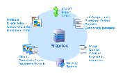
Import Utility: imports data from .Xls, .Dbf, .TXT, .CSV, .MDB formats into Projetex 2005 Database. Projetex 2005 is Project Management Software for Translation Agencies. It tremendously simplifies task of corporate and freelance workflow management, data and files sharing within company and provides multiple benefits for each team member.System Administrator, General...
Category: Business & Finance
Publisher: Translation Agencies Project Management, License: Freeware, Price: USD $0.00, File Size: 1.8 MB
Platform: Windows
GeoBase is a high performance OEM tool for embedding Gis functions in client and server applications. GeoBase has a small memory footprint - both on the hard disk for storage and in RAM during use. Compatible with both .NET and Linux, GeoBase is designed for a rapid development cycle and low deployment cost. The Map Engine displays rich, detailed maps for use in server or client...
Category: Software Development / Compilers & Interpreters
Publisher: Telogis, License: Freeware, Price: USD $0.00, File Size: 87.0 MB
Platform: Windows
Xls Reader is a freeware that you can use to Open, view and print any Microsoft Office Excel( Xls ,Xlsx) document. It's a quick and convenient way to view Excel files on your computer. Xls Reader from FoxPDF lets you open, view Excel Xls, Xlsx and Rtf files as well as TXT files and it doesn't require Microsoft Excel. It can run as a desktop application in...
Category: Business & Finance / Applications
Publisher: FoxPDF Software Inc, License: Freeware, Price: USD $0.00, File Size: 11.1 MB
Platform: Windows
gvSIG project is a free and open source Geoinformation System (Gis), that enables users to interactively visualize, manage, modify and analyze spatial information in the form of digital maps, images and database tables. It is easy to learn, yet versatile and efficient enough for demanding Gis tasks.
Category: Multimedia & Design / Multimedia App's
Publisher: Oxford Archaeology Digital, License: Freeware, Price: USD $0.00, File Size: 273.0 MB
Platform: Windows
Use dbfHeaderEdit to view and edit headers of Dbf files dbfHeaderEdit can modify the following data in Dbf-header: - table type; - last modification date; - count of records; - first record position; - record length; - code page; - CDX and Memo flags; - link to database file; and display names and types of table fileds. Program needs no installation and can start from any media...
Category: Software Development / Misc. Programming
Publisher: ???????? ?????, License: Freeware, Price: USD $0.00, File Size: 198.0 KB
Platform: Windows
FlowHeater is a powerful tool for connecting widely differing data sources and targets using a flexible graphically defined conversion. CSV (text) import/export becomes childs play. Adapters are available for import/export/update of MS Access, MS Excel, MS SQL Server, MySQL, SQLite, PostgreSQL, Oracle, OleDB and ODBC data sources as well as text formats (CSV, TXT, ASC, ASCII, Flat File...). The...
Category: Business & Finance / Database Management
Publisher: FlowHeater GmbH, License: Freeware, Price: USD $0.00, File Size: 9.6 MB
Platform: Windows

The free AvisMap Viewer opens most Gis/CAD and raster image file types and most ArcView, ArcExplorer, and MapInfo projects. Besides just opening and viewing files, the Viewer supports an extensive list of features including visual layer properties control, legend control, thematic mapping, spatial and attribute querying, custom labeling, on-map measurements, hyper-linking, PDF export...
Category: Software Development / Components & Libraries
Publisher: AvisMap GIS Technologies, License: Freeware, Price: USD $0.00, File Size: 22.3 MB
Platform: Windows
The Mapping and Gis License Manager software allows you to manage multiple licenses for the GPS Pathfinder Office software. Using the GPS Pathfinder Office License Administrator software, users of the GPS Pathfinder Office software can choose either a single use or a floating license.
Category: Business & Finance / Business Finance
Publisher: Trimble, License: Freeware, Price: USD $0.00, File Size: 26.8 MB
Platform: Windows
PlanetGIS Explorer is a free viewer for PlanetGIS maps and GIS exchange files.
PlanetGIS Explorer is a free viewer for PlanetGIS maps and Gis exchange files. PlanetGIS Explorer allows you to navigate through maps, query map elements and view attribute information from linked database tables. Also PlanetGIS Explorer allows you to customize the appearance of maps for purposes of creating hardcopy printouts, but does not allow you to save any changes to maps.
Category: Multimedia & Design / Graphics Viewers
Publisher: Planet GIS, License: Freeware, Price: USD $0.00, File Size: 5.4 MB
Platform: Windows
The CDBF Shell extension allows you to view content or structure of Dbf files in the Properties window without opening them. CDBF Shell allows you: copy to the clipboard selected records. copy to the clipboard structure of the table. hide or show deleted records. sort Dbf file by clicking on a column header. set default order of records. switch Ansi/OEM charset (Autodetect...
Category: Utilities
Publisher: WhiteTown Software, License: Freeware, Price: USD $0.00, File Size: 190.3 KB
Platform: Windows
Bytescout Xls Viewer is a safe way to view, print Xls (Excel 97-2003), XLSX (Excel 2007), ODS (Open Office) spreadsheets with MS Office or Open Office NOT REQUIRED. Based on Bytescout.Xls library for .NET .NET developers Export to HTML is supported as well Based on Bytescout.Xls library for .NET (VB, C#, ASP.NET) software developers.
Category: Business & Finance / Spreadsheets
Publisher: ByteScout, License: Freeware, Price: USD $0.00, File Size: 366.5 KB
Platform: Windows
Cityvu is a 3D GIS data viewer able to load CityGML data format from any compatible data source.
Cityvu is a 3D Gis data viewer able to load CityGML data format from any compatible data source.
Cityvu features 3D hardware rendering using OpenGL with a complete navigation system that allows automated tour of the rendered scene. It has been designed to be used to develop customized software solutions, built on the specific needs. Cityvu supports in addition to CityGML,...
Category: Multimedia & Design / Graphics Viewers
Publisher: 3D GIS Cityvu, License: Freeware, Price: USD $0.00, File Size: 9.9 MB
Platform: Windows
The MapSys Cadastral Gis offers specialized functionality for each stage of processing including the digital map creation, plotting cadastral and topographical plans, generating and combining geo-referenced data in order to obtain a validated relational geo-database. This can be used in MapSys or in other Gis programs or database application.
Category: Home & Education / Teaching Tools
Publisher: GEOTOP, License: Freeware, Price: USD $0.00, File Size: 143.9 MB
Platform: Windows