Free Downloads: Coordinate Import
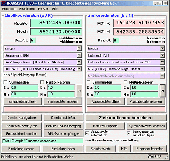
MMS Coordinate Converter is a free utility with which you can convert a survey Coordinate between different systems and datums.
The utility will convert between the Cape (Clarke) / Wgs84 datums with coordinates in Geographical / UTM / LO formats similar to the functions available in Model- and Survey-Maker.
Category: Multimedia & Design / Media Management
Publisher: Model Maker Systems, License: Freeware, Price: USD $0.00, File Size: 6.8 MB
Platform: Windows
The Survey Import and Export program works with AutoCAD (dwg) and Coordinate data in formats such as txt, ascii, and csv. The configurable interface makes matching survey descriptions (as assigned in the field) to text, blocks (with attributes) or various point types, straightforward. SQL drives the included Survey.mdb to support the constuction and management of field book...
Category: Multimedia & Design / Multimedia App's
Publisher: CADD Productivity, License: Shareware, Price: USD $119.00, File Size: 3.1 MB
Platform: Windows
PrimaCode Transform for Windows is a Windows based computer solution built using the Microsoft .
PrimaCode Transform for Windows is a Windows based computer solution built using the Microsoft .Net Framework and designed to best-fit one Coordinate system to another using a least-squares two-dimensional conformal Coordinate transformation.
When the transformation is complete, the two surveys (Coordinate systems) share the same meridian and the same origin, that is...
Category: Business & Finance / Business Finance
Publisher: PrimaCode Technologies, License: Shareware, Price: USD $445.00, File Size: 11.0 MB
Platform: Windows
DraftSight is a drafting automation software tool.
DraftSight is a drafting automation software tool.A Coordinate system determines each point of a drawing surface or entity unambiguosly.DraftSight uses the Cartesian Coordinate system consisting of three Coordinate axes.Axes are arranged orthogonally crossing at the origin.
Category: Multimedia & Design / Image Editing
Publisher: Dassault Systemes, License: Freeware, Price: USD $0.00, File Size: 66.5 MB
Platform: Windows
Coordinate Conversion for Object Oriented Programming!
Coordinate Conversion for Object Oriented Programming! GeoCalc.NET is the latest drag-and-drop component for .NET application development. GeoCalc.NET provides .NET developers seamless Coordinate conversion when creating custom GIS software for said development platform.
The latest version of GeoCalc.NET has full support for HTDP Reference Frames and Coordinate...
Category: Software Development / Misc. Programming
Publisher: Blue Marble Geographics, License: Demo, Price: USD $0.00, File Size: 48.8 MB
Platform: Windows

TRANSDATpro can prove a helpful tool for professionals, providing them with the possibility to perform Coordinate transformations fast and easy by use of the Coordinate reference systems of their choice. TRANSDATpro performs Coordinate Transformations fast and with high accuracy. The Coordinate conversion software supports worldwide thousands of Coordinate...
Category: Home & Education / Science
Publisher: Killet GeoSoftware Ing.-GbR, License: Shareware, Price: USD $270.00, EUR240, File Size: 5.3 MB
Platform: Windows
Do you have coordinates for some places of interest?
Do you have coordinates for some places of interest? Do you want to find them on Earth's surface? There are more than 2,000 Coordinate systems available to make Google Earth follow your interests! Plex.Mark! simply placemarks your world!
Have you found a place in Google Earth and you would like to have the coordinates in your Coordinate system? Plex.Mark! will now make...
Category: Internet / Browser Accessories
Publisher: Plexscape, License: Freeware, Price: USD $0.00, File Size: 601.9 KB
Platform: Windows
GEOPosCalc is an easy to use and powerfull tool for coordinate systems (grid) and datum conversion.
GEOPosCalc is an easy to use and powerfull tool for Coordinate systems (grid) and datum conversion. It does support more than 200 predefined datums, 20 ellipsoids and 10 Coordinate systemsand the ability to define your own datums and ellipsoids.
Category: Home & Education / Science
Publisher: American Outland, License: Shareware, Price: USD $40.00, File Size: 4.7 MB
Platform: Windows
TRANSDAT Geosoftware executes Coordinate transformations and geodetic datum shifts between lots of Coordinate and reference systems of Germany, Europe, America, Australia and world wide in high quality and with high performance: 1. The German Coordinate and Reference Systems of the old and new Federal Countries including the 40 Prussian Soldner Land Registers and Soldner...
Category: Business & Finance / Applications
Publisher: Killet Softwareentwicklung GbR, License: Shareware, Price: USD $230.00, File Size: 2.6 MB
Platform: Windows
Direct coordination, an advanced search engine to define and coordinate Schneider Electric devices.
Direct coordination, an advanced search engine to define and Coordinate Schneider Electric devices. You define upstream and downstream the electrical constraints of your protective system. Search and Coordinate between two devices. You define the electrical constraints that your single search device must support. Search and select.
Category: Multimedia & Design / Multimedia App's
Publisher: Schneider Electric, License: Demo, Price: USD $0.00, File Size: 228.3 MB
Platform: Windows

TRANSDAT geosoftware executes Coordinate transformations and geodetic datum shifts between many Coordinate and reference systems of America, Australasia, Europe, Germany special and world-wide, with high precision and high speed: 1.The current and historical Coordinate and reference systems of all countries of the European Union (EU) including the eastern extensions and the...
Category: Home & Education / Science
Publisher: Killet Software Ing.-GbR, License: Shareware, Price: USD $170.00, EUR160, File Size: 4.4 MB
Platform: Windows
In the Dynamic Link Library GeoDLL geodesic functions like Coordinate transformation, datum changes, meridian strip changes, user defined Coordinate and reference systems, distance calculation, maps functions, Digital Elevation Models and more geodesic functions are contained to bind them into own applications. WINDOWS operating system allows building of function libraries...
Category: Software Development
Publisher: Killet Softwareentwicklung GbR, License: Shareware, Price: USD $290.00, File Size: 999.9 KB
Platform: Windows
 Shareware
GeoDLL is a Geodetic Development Kit / Geodetic Function Library with worldwide 2D and 3D Coordinate Transformation, Datum Shift, Meridian Convergence and Extra Parameter with highest accuracy. Furthermore: Helmert and Molodensky Parameters, NTv2, HARN, INSPIRE, EPSG, Digital Elevation Model (DEM), distance and Time Zone calculations and much more. GeoDLL for geodetic and GIS development...
Category: Software Development / Components & Libraries
Publisher: Killet GeoSoftware Ing.-GbR, License: Shareware, Price: USD $560.00, EUR500, File Size: 5.4 MB
Platform: Windows
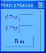
Moves mouse to desired coordinate by the push of a button.
Moves mouse to desired Coordinate by the push of a button. Useful with macro applications for clicking certain areas of the screen when you are not there.This will take up very little memory so as to not slow down other utilities running on the system. The interface is made very small to keep it from taking up space on the screen and interfering with other running macros.
Category: Web Authoring / Web Design Utilities
Publisher: Exterior House Color, License: Freeware, Price: USD $0.00, File Size: 20.0 KB
Platform: Windows
Shareware
The Eye4Software Coordinate Calculator is an easy to use tool to perform map or GPS Coordinate conversions. The software can be used to transform a single Coordinate or a batch of coordinates read from a comma separated, database or ESRI shapefiles. The software is shipped with a MS Access database file, containing more then 3500 ellipsoid, map datum and map grid...
Category: Business & Finance / Calculators
Publisher: Eye4Software B.V., License: Shareware, Price: USD $49.00, EUR39, File Size: 3.2 MB
Platform: Windows
Draw points in AutoCAD and generate 3D models using data in Excel.
XLPoints Plus is the easiest way to massively draw points in AutoCAD and generate 3D models using Coordinate data in Excel. Key Features: - Quickly draw points using Coordinate data in Excel. - Create new drawings or update existing ones by establishing an open channel with AutoCAD. - Create "true" 3D faces or simply connect all points with a 3D polyline. For the 3D...
Category: Multimedia & Design
Publisher: Productivity Tools, License: Shareware, Price: USD $30.00, File Size: 1.7 MB
Platform: Windows
Design elements of this product coordinate with the following products: Smile and Joy Pack.
Design elements of this product Coordinate with the following products: Smile and Joy Pack. It has high-resolution (print quality) JPG and PNG files (with transparency). You may use graphics to customize your own personal blog or website as long as credit notice is given to the designer.
Category: Desktop Enhancements / Shell & Desktop Managers
Publisher: StoryRock Inc., License: Freeware, Price: USD $0.00, File Size: 16.5 MB
Platform: Windows
JCapPM allows you to associate coordinate information (x/y) to each photo.
JCapPM allows you to associate Coordinate information (x/y) to each photo. JCapPM can communicate with Google Earth which allows you to geotag all your files using Google Earth. You can use JCapPM's filter in order to geotag only filtered photos at once.
Category: Home & Education / Miscellaneous
Publisher: ZeroG Software, License: Freeware, Price: USD $0.00, File Size: 2.5 MB
Platform: Windows
Shareware
GPS Mapping Software for Windows, Loading topographic maps, realtime navigation, track recording, manage GPS devices and more. The software can be used with various map formats including: GeoTiff, BSB Nautical Charts, AutoCad DXF files, ESRI Shapefiles. Using calibration you can also use scanned or downloaded JPG, BMP, GIF, PNG and TIF maps. The software can be used for survey, research, track...
Category: Home & Education / Science
Publisher: Eye4Software B.V., License: Shareware, Price: USD $149.00, EUR99, File Size: 11.1 MB
Platform: Windows
Design elements of this pack coordinate with the following products: Splendor Pack.
Design elements of this pack Coordinate with the following products: Splendor Pack. You may use graphic elements in layouts and other craft projects that are submitted to scrapbooking magazines for publication, online galleries, or other non-retail web communities, as long as proper credit is given to the designer by name, including credit
notice of any graphic you have altered in...
Category: Desktop Enhancements / Shell & Desktop Managers
Publisher: StoryRock Inc., License: Freeware, Price: USD $0.00, File Size: 23.5 MB
Platform: Windows
OBJ Import for Solid Edge is a Wavefront (.obj) file Import add-in for Solid Edge®. This plug-in gives Solid Edge the ability to Import geometric data from OBJ files. OBJ Import for Solid Edge reads polygon mesh data stored in OBJ files and imports it into Solid Edge. A polygon mesh in an OBJ file is comprised of a set of triangular and/or quad faces. OBJ...
Category: Multimedia & Design
Publisher: SYCODE, License: Commercial, Price: USD $195.00, File Size: 1.3 MB
Platform: Windows
ProLat DLL is a complete coordinate conversion toolkit for most programming languages and Excel.
ProLat DLL is a complete Coordinate conversion toolkit for most programming languages and Excel. Its ease-of-use and industry standard accuracy make it an ideal solution. ProLat DLL software requires one license for each developer work-station where it is used for development even if the software is installed on a server.
Category: Software Development / Misc. Programming
Publisher: Effective Objects, License: Shareware, Price: USD $250.00, File Size: 2.6 MB
Platform: Windows
GPS Sway is a simple coordinate conversion program.
GPS Sway is a simple Coordinate conversion program. It handles all forms of latitude and longitude (degrees, degrees minutes, degrees minutes seconds) as well as UTM coordinates and will convert from any form to another. It also handles signs or character direction.
Category: Multimedia & Design / Media Management
Publisher: GPSFileDepot, License: Freeware, Price: USD $0.00, File Size: 154.2 KB
Platform: Windows