Free Downloads: National Geographic Explorer
Amazing photos, the most successful, incredible views and precise focuses.
Amazing photos, the most successful, incredible views and precise focuses. There?s no need to tell a lot about the quality of National Geographic?s pictures.
Category: Desktop Enhancements / Screensavers
Publisher: 3d-screensaver-jam.com, License: Freeware, Price: USD $0.00, File Size: 3.4 MB
Platform: Windows, Mac, Vista, 2008
TOPO! Explorer is both the website you are viewing now and a free desktop application created by National Geographic Maps. The website contains freely browsable topographic maps, aerial imagery, hybrids, and a National recreation database filled with updated trails, points-of-interest, photos, videos, trail reports, and descriptions from professional and community...
Category: Home & Education / Miscellaneous
Publisher: National Geographic Maps, License: Freeware, Price: USD $0.00, File Size: 22.9 MB
Platform: Windows
DIVA-GIS is a free computer program for mapping and Geographic data analysis (a Geographic information system (GIS). With DIVA-GIS you can make maps of the world, or of a very small area, using, for example, state boundaries, rivers, a satellite image, and the locations of sites where an animal species was observed.
Category: Business & Finance / Applications
Publisher: diva-gis, License: Freeware, Price: USD $0.00, File Size: 3.8 MB
Platform: Windows
Working with raster imagery doesn't have to be complicated.
Working with raster imagery doesn't have to be complicated. Geographic Imager® enhances Adobe Photoshop to make working with spatial imagery quick and efficient. It adds tools to import, edit, manipulate and export geospatial images such as aerial and satellite imagery. Enjoy the use of native Adobe Photoshop functions such as transparencies, filters, pixel editing, and image...
Category: Multimedia & Design / Fonts
Publisher: Avenza Systems Inc., License: Shareware, Price: USD $0.00, File Size: 0
Platform: Windows
SAGA is a free Geographic information system (GIS), with a special 'Application Programming Interface' (API) for Geographic data processing. This API makes it easy to implement new algorithms. The SAGA API supports grid data, vector data, and tables.
Category: Software Development / Misc. Programming
Publisher: aringel, oconrad, reklov_w, License: Shareware, Price: USD $0.00, File Size: 9.4 MB
Platform: Windows
Hanzi Explorer is a powerful and intelligent learning system based on plenty of valuable resources for efficiently mastering Chinese.Hanzi Explorer features a unique writing animation, every Hanzi is derived from its etymology or memory skills to color components and animated in big size stroke by stroke. These effects will dramatically enhance your memory efficiency. The voice of...
Category: Home & Education / Miscellaneous
Publisher: Hanyu, License: Shareware, Price: USD $49.00, File Size: 12.5 MB
Platform: Windows
GeoSurveillance is software that combines spatial statistical routines with some basic Geographic Information Systems (GIS) functions to carry out retrospective and prospective statistical tests for the detection of Geographic clustering. In this software, the focus is primarily on the spatial statistical analysis. Consequently, full GIS functionality is not provided. GIS...
Category: Home & Education / Miscellaneous
Publisher: NCGIA, License: Freeware, Price: USD $0.00, File Size: 2.4 MB
Platform: Windows
OrbisGIS is a Geographic Information System developped for and by research.
OrbisGIS is a Geographic Information System developped for and by research. This cross-platform GIS is developed by French IRSTV institute and is able to manipulate and create vectorial and raster spatial data. OrbisGIS is distributed under GPL 3 license.
Category: Home & Education / Miscellaneous
Publisher: Free Software Foundation, Inc., License: Freeware, Price: USD $0.00, File Size: 15.4 MB
Platform: Windows
Have the national yellow pages at your fingertips.
Have the National yellow pages at your fingertips. Lookup phone numbers, street addresses, and websites of any business in the US.
Category: Home & Education / Miscellaneous
Publisher: AreaG2, License: Freeware, Price: USD $0.00, File Size: 542.7 KB
Platform: Windows
Korti is a Google Earth plugin which allows you to see the unique 3D satellite map of Korti within your Google Earth application.
Korti provides you a detailed satellite imagery and Geographic information about this Geographic place.
To have Korti installed on your PC, first install for free Google Earth and then Korti 3D map plugin. After that, simply double click...
Category: Multimedia & Design / Multimedia App's
Publisher: Maplandia, License: Freeware, Price: USD $0.00, File Size: 309 B
Platform: Windows
Know Your USA is a popular geographycal software for learning all about the United States.
Know Your USA is a popular geographycal software for learning all about the United States. Every major Geographic and geopolitical feature of the United States is included. The main topics featured in Know Your USA: About the USA, Regions, States, State Capitals, Major Cities, Rivers, Mountains, Lakes, Oceanography and National Parks
Category: Home & Education / Miscellaneous
Publisher: EdWare, License: Shareware, Price: USD $199.00, File Size: 42.8 MB
Platform: Windows
 Shareware
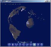
Wandering IPs is geolocation software. Once launched it monitors TCP connections made to or from your PC, identifies remote IP adresses and then tries to determine their Geographic locations. Results are displayed on textured. iluminated accordingly to time zone you're currently in, 3D globe. Apart from locating endpoinds, it can be used to determine the route taken by packets across an...
Category: Internet / Tools & Utilities
Publisher: Marek Jablonski, License: Shareware, Price: USD $12.99, File Size: 1.0 MB
Platform: Windows
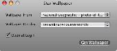
Star Wallpaper for Mac is a very interesting software!
Star Wallpaper for Mac is a very interesting software! It can automatically updates your desktop background from your choice of image sources everyday! The software will auto find photos for you, Such as automatically finds great photos from National Geographic website and allows you to use them as your desktop wallpaper.
Category: Desktop Enhancements / Misc. Themes
Publisher: www.star-watermark.com, License: Shareware, Price: USD $1.99, File Size: 390.0 KB
Platform: Mac
Get a full 3D satellite map view of El Petacon on your PC.
Get a full 3D satellite map view of El Petacon on your PC. If you have already installed Google Earth, you will be able to view the El Petacón 3D map. You will enjoy a beautiful view of this Geographic place and you will have the world's Geographic information at your fingertips.
Category: Home & Education / Miscellaneous
Publisher: Maplandia, License: Freeware, Price: USD $0.00, File Size: 331 B
Platform: Windows
PLDT Watchpad, myDSL subscribers can watch TV shows, films, and more over the internet.
PLDT Watchpad, myDSL subscribers can watch TV shows, films, and more over the internet. Available channels now include National Geographic, Cartoon Network, Pinoy Box Office, CNN, Animax Mobile, CNBC, and GMA 7, with more coming soon.
Best experienced starting with myDSL Plan 1299, Watchpad is available for free to all myDSL subscribers nationwide.
Category: Audio / Utilities & Plug-Ins
Publisher: PLDT, License: Freeware, Price: USD $0.00, File Size: 5.4 KB
Platform: Windows
PostGIS is unique software that adds support for Geographic objects to the PostgreSQL object-relational database.
In effect, PostGIS "spatially enables" the PostgreSQL server, allowing it to be used as a back-end spatial database for Geographic information systems (GIS), much like ESRI's SDE or Oracle's Spatial extension. PostGIS follows the...
Category: Business & Finance / Database Management
Publisher: Refractions Research, License: Shareware, Price: USD $0.00, File Size: 11.2 MB
Platform: Windows
Here you will find the World Wind SDK for Java.
Here you will find the World Wind SDK for Java. With this, developers can embed World Wind technology in their own applications.
World Wind Java provides a rich set of features for displaying and interacting with Geographic data and representing a wide range of geometric objects.
- Open-source, high-performance 3D Virtual globe API and SDK
- Adds...
Category: Home & Education / Miscellaneous
Publisher: NASA, License: Shareware, Price: USD $0.00, File Size: 73.5 MB
Platform: Windows
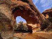
This screensaver will show you off the beautiful images of national canyons of USA.
This screensaver will show you off the beautiful images of National canyons of USA. You will see on the screen of your PC the views from Arizona, Utah, Montana, California, Georgia and Nevada canyons. Enjoy the unusual rocky formations, stunning rich colors and wild nature of american canyons.
Category: Desktop Enhancements / Screensavers
Publisher: Mega-Screens.com, License: Freeware, Price: USD $0.00, File Size: 4.7 MB
Platform: Windows
The leading GPS interface tool for Windows!
The leading GPS interface tool for Windows! GPS answers the significant world demand for accurate, viable and cost effective positioning systems. The Geographic Tracker delivers all of the power and utility of GPS to the Windows environment by allowing you to link a GPS receiver to other Microsoft Windows applications through standard Windows DDE messaging.
Category: Home & Education / Miscellaneous
Publisher: Bluemarble Geographics, License: Shareware, Price: USD $0.00, File Size: 0
Platform: Windows
gvSIG Desktop is a powerful Geographic information system (GIS) designed to offer a free solution to all needs related to Geographic information management. It is characterized as a comprehensive, easy to use solution, it adapts to the needs of any GIS user. Access to the most common formats, both vector and raster, both local and remote is possible. It integrates with OGC...
Category: Multimedia & Design / Multimedia App's
Publisher: gvSIG Association, License: Freeware, Price: USD $0.00, File Size: 149.5 MB
Platform: Windows
NCLEX Tutorial contains two National nurse licensure examinations: the National Council Licensure Examination for Registered Nurses (NCLEX-RN) and the National Council Licensure Examination for Practical Nurses (NCLEX-PN).
These two examinations are used by the Boards of Nursing to test entry-level nursing competence of candidates for licensure as Registered Nurses...
Category: Home & Education / Teaching Tools
Publisher: Pearson Education, Inc., License: Shareware, Price: USD $150.00, File Size: 56.4 MB
Platform: Windows
Christine-GIS is a useful, easy-to-use tool that brings geographic information to your desktop.
Christine-GIS is a useful, easy-to-use tool that brings Geographic information to your desktop. Christine gives you the power to visualize, explore, query and analyze data spatially. A key feature of Christine is that it's easy to load tabular data, such as dBASE files and data from database servers.
Category: Home & Education / Miscellaneous
Publisher: christine-gis.com, License: Shareware, Price: USD $0.00, File Size: 0
Platform: Windows
National Clock Design Tool software is used to aid part selection, loop filter design, and simulation of timing device solutions.
Enter desired output frequencies and optionally a reference frequency and the tool provides: National devices meet the specified requirements, divider values, and recommended loop filter to minimize jitter.
Category: Utilities / Misc. Utilities
Publisher: National Semiconductor, License: Shareware, Price: USD $0.00, File Size: 12.9 MB
Platform: Windows
World of Zoo is the only game that pushes you past the fences and into a world of your own zoo.
World of Zoo is the only game that pushes you past the fences and into a world of your own zoo. You can create and customize your zoo experience and develop hands on relationships to earn the trust and love of your animals. Get up close and personal with the world’s most amazing zoo animals through hands on interaction. The game includes an Animal Creator that enables you to create...
Category: Games / Simulations
Publisher: THQ Inc., License: Commercial, Price: USD $19.99, File Size: 0
Platform: Windows
GeoVISTA Studio is an open software development environment designed for geospatial data.
GeoVISTA Studio is an open software development environment designed for geospatial data. Studio is a programming-free environment that allows users to quickly build applications for geocomputation and Geographic visualization.
Studio is a modularly designed interface that allows the integration of various forms of Geographic data to be analyzed and displayed in a dynamic...
Category: Multimedia & Design / Image Editing
Publisher: GeoVista, License: Shareware, Price: USD $0.00, File Size: 0
Platform: Windows