Free Downloads: Add Gps Tracking To Autocad
Are you looking for a Gps Tracking system or a Gps tracker but haven't found the one that is ideal for you? Then, look no further as our site has the best deals and information about the kind of Gps tracker you should buy.
Category: Security & Privacy / Other
Publisher: Top GPS Tracking Srl., License: Freeware, Price: USD $0.00, File Size: 722.0 KB
Platform: Windows
GPSCAD Transfer is an application for transferring points between a gps device and autocad.
GPSCAD Transfer is an application for transferring points between a Gps device and Autocad. The present version works with a Magellan Gps device, but the next release will also work with a Garmin Gps device. It allows you to convert latitude and longitude to utm zone nad 83 in either the US or in metric measurement system.
Category: Multimedia & Design / Image Editing
Publisher: Timberwolf Software Solutions, LLC, License: Shareware, Price: USD $0.00, File Size: 2.6 MB
Platform: Windows
 Shareware
Gps Mapping Software for Windows, Loading topographic maps, realtime navigation, track recording, manage Gps devices and more. The software can be used with various map formats including: GeoTiff, BSB Nautical Charts, Autocad DXF files, ESRI Shapefiles. Using calibration you can also use scanned or downloaded JPG, BMP, GIF, PNG and TIF maps. The software can be used for...
Category: Home & Education / Science
Publisher: Eye4Software B.V., License: Shareware, Price: USD $149.00, EUR99, File Size: 11.1 MB
Platform: Windows
Shareware
Gps Mapping Software for Windows, Loading topographic maps, manage Gps devices and more. The software can be used with various map formats including: GeoTiff, BSB Nautical Charts, Autocad DXF files, ESRI Shapefiles. Using calibration you can also use scanned or downloaded JPG, BMP, GIF, PNG and TIF maps. The software can be used for survey, research, track and trace, real...
Category: Home & Education / Science
Publisher: Eye4Software B.V., License: Shareware, Price: USD $75.04, EUR49, File Size: 6.7 MB
Platform: Windows
VIETMAP Gps Fleet Management is a great Gps Tracking software for companies that need to know where are all the cars in some moment. It is a great and helpful software when you want to check out if your drivers are on schedule. This software also helps you if your car is stolen.
Category: Business & Finance / Business Finance
Publisher: VIETMAP, License: Demo, Price: USD $0.00, File Size: 111.6 MB
Platform: Windows
Ideal for business or families.
Ideal for business or families. Revolutionary GSM mobile phone Tracking technology now allows registered users to locate a mobile and then displays the
GSM mobile phone Tracking system via the Gps-TRACK satellite network. Based on repeater triangulation, the system tracks mobile phones using Gps Java ME. Find a mobile - Worried where your children, car, items are?...
Category: Internet / Communications
Publisher: 8Mail, License: Freeware, Price: USD $0.00, File Size: 13.0 KB
Platform: Windows
Beacon Gps Tracking Unit features utility Gps receiver for both sport (country hike) & normal navigation, implement SIRF 3rd generation Gps receiver, electronic gyro compass function, large LCM (128 x 128 dots) screen with dual color back light indicates data. The software is only supported by Windows operating system.
Category: Internet / Communications
Publisher: Winplus, License: Freeware, Price: USD $0.00, File Size: 11.7 MB
Platform: Windows
CadTempo is a time keeping and tracking solution for CAD and related engineering documents.
CadTempo is a time keeping and Tracking solution for CAD and related engineering documents.
Edit and elapsed time are automatically recorded. The CAD supervisor, project manager or other big wig can easily view the accumulated document time as well as the work week history.
As the replacement product of Chronos for Autocad, CadTempo extends time...
Category: Multimedia & Design / Image Editing
Publisher: Engineered Design Solutions, License: Shareware, Price: USD $49.95, File Size: 2.1 MB
Platform: Windows
Gps Tracker Data Logger acts as the server and allows you to collect data from an unlimited number of various Gps trackers simultaneously. The obtained data is processed, uniformed and written to a log file or a database. Also, the program has a set of interfaces so other applications can get data in real time.
Gps Tracker Data Logger can convert data into other...
Category: Internet / Misc. Servers
Publisher: AGG Software, License: Shareware, Price: USD $80.83, File Size: 11.8 MB
Platform: Windows
!SlingShot introduces more than 60 new commands to your Autocad. Make the most of your Autocad LT software.
!Slingshot provides the most popular set of useful enhancemnt tools for use in Autocad and Autocad LT. Maximise your Autocad software with this seamless tool - available for versions 2000 - 2010 and beyond.
!SlingShot offers a generous...
Category: Multimedia & Design / Image Editing
Publisher: drcauto, License: Demo, Price: USD $0.00, File Size: 7.0 MB
Platform: Windows
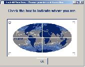
Have a Gps and a laptop? Use this to find your way. Make patterns or a trail to share with others. When the application starts, you may pick your area of operations - be it North America, South America, Europe and Asia, or Australia. Your quadrant is determined by where you are in relation to the Equator and the Prime Meridian. Tracking of your position is automatically enabled...
Category: Home & Education / Miscellaneous
Publisher: LogicAll Solutions, LLC, License: Freeware, Price: USD $0.00, File Size: 4.6 MB
Platform: Windows
Lab Scanner is your small personal Internet Tracking Utility!
Lab Scanner is your small personal Internet Tracking Utility! Combing the power of a Gps System with Lab Scanner you are able to track the geographical country of almost all the IP Addresses from a database of 45870 Ranges. You can also Trace an IP Address to find the routes you must go trough to reach it, as well as Ping it and get information regarding Loss, Packets and Network...
Category: Internet / Tools & Utilities
Publisher: Reohix, License: Freeware, Price: USD $0.00, File Size: 3.3 MB
Platform: Windows
GPS tracking of persons and vehicles in real time.
Gps Tracking of persons and vehicles in real time.
Determine current position, speed, altitude and direction of movement.
Users can monitor real-time movement of their vehicles (or peoples) in different types of maps, or specify the period and review the previous motion, speed, distance and so on.
Category: Home & Education / Miscellaneous
Publisher: RIA Software Co, License: Shareware, Price: USD $40.00, File Size: 1.5 MB
Platform: Windows
FREE GPS Software for your Garmin, Magellan or Lowrance GPS.
FREE Gps Software for your Garmin, Magellan or Lowrance Gps.
EasyGPS is the fast and easy way to upload and download waypoints, routes, and tracks between your Windows computer and your Garmin, Magellan, or Lowrance Gps. EasyGPS lists all of your waypoints on the left side of the screen, and shows a plot of your Gps data on the right. Use EasyGPS to back up...
Category: Internet / Communications
Publisher: TopoGrafix, License: Freeware, Price: USD $0.00, File Size: 3.9 MB
Platform: Windows
Every engineer who use Autodesk AutoCAD know that AutoCAD is a very powerful CAD software.
Every engineer who use Autodesk Autocad know that Autocad is a very powerful CAD software. Using this software, you can save much time and improve your work quality.
But when it comes to draw a Table, it's not convenient at all. It's really boring and knotty to Add a table to your Autocad drawing. You have to draw many lines, Add many text objects to build...
Category: Multimedia & Design / Image Editing
Publisher: LyraSoft, License: Shareware, Price: USD $49.50, File Size: 913.0 KB
Platform: Windows
My Gps Logger 1.01 is a program designed to be used with My Fuel Tax 4.0. With My Gps Logger you can log all the locations where your truck has been to a monthly data file. This data file can later be imported into My Fuel Tax 4.0 by calculating the miles in state using Microsoftâ Mappoint. This is what you will need to use My Gps Logger with My Fuel Tax:a laptop with...
Category: Home & Education / Miscellaneous
Publisher: Spinnaker Software Solutions, License: Freeware, Price: USD $0.00, File Size: 477.7 KB
Platform: Windows
ComputationalCAD is a computational geometry add-on for AutoCAD.
ComputationalCAD is a computational geometry Add-on for Autocad. Its industry-strength algorithms are suitable for large-scale computations. ComputationalCAD supports Delaunay triangulations of large point clouds in Autocad. You can also triangulate edge constraints and define arbitrary shaped outer bounds, holes and islands. ComputationalCAD enables real-time orbit of...
Category: Multimedia & Design / Image Editing
Publisher: ceometric, License: Shareware, Price: USD $480.68, File Size: 17.1 MB
Platform: Windows
Shareware
DWF to DWG Converter featured with importing DWF files into editable DWG files, very simple to use. This is Autocad Add-in, and request Autocad full to run. Works with Autocad 2011 thru R14. Features highlight: Supports the new DWF v6.0 multi page specification; All DWF elements generated by Autocad "plot to DWF" are supported, including true type fonts,...
Category: Multimedia & Design / Graphics Viewers
Publisher: AutoDWG, License: Shareware, Price: USD $120.00, File Size: 3.0 MB
Platform: Windows
Have a Gps and a laptop? Use this to find your way. Make patterns or a trail to share with others. When the application starts, you may pick your area of operations - be it North America, South America, Europe and Asia, or Australia. Your quadrant is determined by where you are in relation to the Equator and the Prime Meridian. Tracking of your position is automatically enabled...
Category: Home & Education / Miscellaneous
Publisher: LogicAll Solutions, LLC, License: Freeware, Price: USD $0.00, File Size: 4.6 MB
Platform: Windows
Shareware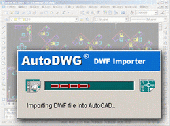
DWF to DWG Converter featured with importing DWF files into editable DWG files, very simple to use. This is Autocad Add-in, and request Autocad full to run. Works with Autocad 2012 thru R14. Features highlight: Supports the new DWF v6.0 multi page specification; All DWF elements generated by Autocad "plot to DWF" are supported, including true type fonts,...
Category: Multimedia & Design / Graphics Viewers
Publisher: AutoDWG, License: Shareware, Price: USD $120.00, File Size: 4.6 MB
Platform: Windows
InnerSoft CAD is a Add-on component for Autocad that allows you to Export the values of an Area/ Length property or coordinates to an Excel Sheet.
Take measurements on Autocad for construction project budgets.
Create, open or save different libraries, which contain a series of Autocad drawings (*.dxf or *.dwg) organized by books.
Category: Multimedia & Design / Image Editing
Publisher: InnerSoft, License: Shareware, Price: USD $70.00, File Size: 2.9 MB
Platform: Windows
VisualGPSXP is a general purpose utility for monitoring the output of a GPS receiver.
VisualGPSXP is a general purpose utility for monitoring the output of a Gps receiver. Using the NMEA data from the Gps receiver, VisualGPSXP will display various statuses graphically.
Tools such as a survey utility average the position and shows accuracy of the Gps receiver in a static application.
Main features:
- Multiple connection...
Category: Home & Education / Miscellaneous
Publisher: VisualGPC, License: Shareware, Price: USD $25.00, File Size: 1.1 MB
Platform: Windows
Shareware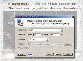
FlashDWG is a DWG to Flash converter. Converting dwg to flash(Autocad to Flash, dwg to swf) is the best way to share and publish Autocad DWG files, better than PDF, better than DWF.no need of additional viewer or plug-in to view flash. FlashDWG is a vector to vector converter, so you can zoom in, zoom out the drawing to see the details of the drawing. FlashDWG is an...
Category: Multimedia & Design / Graphics Viewers
Publisher: AutoDWG, License: Shareware, Price: USD $198.00, File Size: 3.1 MB
Platform: Windows
Shareware
Virtual Gps is a Gps simulator software. You can use it to simulate a Gps receiver unit connected to your system. It's ideal when you need Gps input, but you have no signal or for development purposes. It supports various NMEA sentences, so it can be used with any Gps mapping software. You can use it using a null-modem cable connected to two physical serial...
Category: Internet / RSS & Web Blog Tools
Publisher: Zyl Soft, License: Shareware, Price: USD $39.99, File Size: 856.0 KB
Platform: Windows
3DM Import for Autocad is a Rhinoceros® 3DM file import plug-in for Autocad®. This plug-in gives Autocad the ability to import geometric data from 3DM files. 3DM Import for Autocad offers seamless conversion of 3DM geometry to Autocad's DWG geometry. The integrity of layers, blocks, block instances or inserts, dimensions, etc. are maintained across the...
Category: Multimedia & Design
Publisher: SYCODE, License: Commercial, Price: USD $195.00, File Size: 3.3 MB
Platform: Windows