Free Downloads: Altitude Gps Windows Mobile H
Develop precise, efficient, and reliable location-based services with this multithreaded framework for desktop and Mobile devices, including PocketPC, Tablet PC and now Smartphone! Over fifty classes in one lightweight assembly gives you unparalleled features while saving you hundreds of dollars in development and testing.
Gps.NET is loaded with features,...
Category: Software Development / Components & Libraries
Publisher: StormSource Software, LLC, License: Commercial, Price: USD $98.00, File Size: 4.6 MB
Platform: Windows
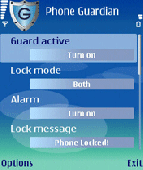
Are you afraid that one day somebody will steal your expensive Series 60 smartphone or you may just leave it and someone can use your confidential data? Just stop worrying and secure your phone with Phone Guardian.
In case your Mobile is forgotten or stolen, Phone Guardian will allow you to remotely secure and auto lock your Symbian Mobile by sending a lock...
Category: Security & Privacy / Access Control
Publisher: SymbianGuru, License: Shareware, Price: USD $12.99, File Size: 291.0 KB
Platform: Windows
Create the GeoDatabase for the entire world. This program create the geographical location Latitude, Longitude, and Altitude (Elevation) for every city, village, region, state, county in the World. The program crawls the data from the website www.heavens-above.com which collect data from US Geological Survey for the USA (and dependencies) and The National Imaging and Mapping Agency for...
Category: Software Development
Publisher: Mewsoft, License: Freeware, Price: USD $0.00, File Size: 1.1 MB
Platform: Windows
 Shareware
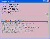
Virtual Gps is a Gps simulator software. You can use it to simulate a Gps receiver unit connected to your system. It's ideal when you need Gps input, but you have no signal or for development purposes. It supports various NMEA sentences, so it can be used with any Gps mapping software. You can use it using a null-modem cable connected to two physical serial...
Category: Internet / RSS & Web Blog Tools
Publisher: Zyl Soft, License: Shareware, Price: USD $39.99, File Size: 856.0 KB
Platform: Windows
The program accepts NMEA GPS sentences from most GPS receivers that connect to a USB port.
The program accepts NMEA Gps sentences from most Gps receivers that connect to a USB port.
The program can display satellite images of waypoint locations on the track plotter.
Is a free software for recording , monitoring and plotting Gps data, very useful and very easy.
Category: Home & Education / Miscellaneous
Publisher: Club Cruceros de La Paz A.C., License: Freeware, Price: USD $0.00, File Size: 10.6 MB
Platform: Windows

OkMap is a Gps and map software that:
-Works with vectorial maps and calibrates raster maps
-Organizes paths by creating waypoints, routes and tracks
-Uploads/downloads data to/from your Gps
-Uses Altitude DEM data
-Supports Gps real-time navigation
-Sends/receives vehicles position and display tracks on maps in real time
-Provides autorouting...
Category: Business & Finance / Applications
Publisher: Gian Paolo Saliola, License: Freeware, Price: USD $0.00, File Size: 20.2 MB
Platform: Windows
Golf GPS Devices toolbar for internet explorer.
Golf Gps Devices toolbar for internet explorer. Find golf Gps devices are great bargain prices. We have all the latest golf Gps devices for sale both new and used. Whether you're looking for the iGolf, Golf Buddy, GolfLogix, SonoCaddie, or SkyCaddie, you can find it here along with their accessories. We are always searching our networks to bring you the best deals on golf...
Category: Internet / Browsers
Publisher: Golf GPS Devices, License: Freeware, Price: USD $0.00, File Size: 1.1 MB
Platform: Windows
GPSMapEdit is an application designed for visual authoring of Gps-maps in various cartographic formats: Polish format, Garmin MapSource, Lowrance MapCreate, Navitel Navigator (navigation software for Windows Mobile, Android, Symbian, iPhone), ALAN Map 500/600, Holux MapSho, and custom POIs and speedcams.
The program may also load and convert Gps-tracks,...
Category: Utilities / Misc. Utilities
Publisher: Konstantin Galichsky, License: Shareware, Price: USD $65.00, File Size: 2.4 MB
Platform: Windows
Windows Mobile platform time synchronization tools.
Windows Mobile platform time synchronization tools. Support Gps, gprs, sms, wifi, usb, sntp, http, and other forms of time synchronization. Support SmartPhone, PPC and PDA evices.
Category: Utilities / System Surveillance
Publisher: yesmobile, License: Shareware, Price: USD $12.00, File Size: 41.0 KB
Platform:
Are you looking for a Gps tracking system or a Gps tracker but haven't found the one that is ideal for you? Then, look no further as our site has the best deals and information about the kind of Gps tracker you should buy.
Category: Security & Privacy / Other
Publisher: Top GPS Tracking Srl., License: Freeware, Price: USD $0.00, File Size: 722.0 KB
Platform: Windows
The navigation device is a kind of mini computer which contains a GPS satellite navigation receiver.
The navigation device is a kind of mini computer which contains a Gps satellite navigation receiver. This allows the device to determine its current position. At least 4 satellites need to be received in order to be able to perform acceptable navigation. The fifth satellite is required to obtain an Altitude. As navigation takes place in a dynamic state, there is scarcely any...
Category: Business & Finance / Business Finance
Publisher: United Navigation, License: Freeware, Price: USD $0.00, File Size: 13.8 MB
Platform: Windows
With our locr PC software "locr Gps Photo for Windows" you can manage to automatically geotag numerous photos simultaneously. You just require a digital camera, a Gps data logger and the application "locr Gps Photo for Windows".
There are two ways to geotag your photos: The photos can be tagged manually or automatically. For automatic...
Category: Multimedia & Design / Multimedia App's
Publisher: locr, License: Freeware, Price: USD $0.00, File Size: 490.8 KB
Platform: Windows
Gps Software for Garmin. Download waypoints, routes and tracks from Garmin Gps. Upload waypoints, routes and tracks to Garmin Gps. Excel and Text files supported! This software is very easy to use!
Category: Utilities / System Utilities
Publisher: Oy Frontbase Ltd, License: Shareware, Price: USD $29.95, File Size: 1.4 MB
Platform: Windows
GPS-CCD:is a novel computational program for the
Prediction of Calpain Cleavage Sites.
Gps-CCD:is a novel computational program for the
Prediction of Calpain Cleavage Sites.
The online service and local packages of Gps-CCD 1.0 were
implemented in JAVA/. For the online service, we tested the Gps-CCD1.0 on a variety of internet browsers, including Internet Explorer 6.0, Netscape Browser 8.1.3 and Firefox 2 under the Windows XPOperating...
Category: Web Authoring / JavaScript
Publisher: The CUCKOO Workgroup, License: Freeware, Price: USD $0.00, File Size: 19.2 MB
Platform: Windows
Shareware
Gps Mapping Software for Windows, Loading topographic maps, realtime navigation, track recording, manage Gps devices and more. The software can be used with various map formats including: GeoTiff, BSB Nautical Charts, AutoCad DXF files, ESRI Shapefiles. Using calibration you can also use scanned or downloaded JPG, BMP, GIF, PNG and TIF maps. The software can be used for...
Category: Home & Education / Science
Publisher: Eye4Software B.V., License: Shareware, Price: USD $149.00, EUR99, File Size: 11.1 MB
Platform: Windows
Commercial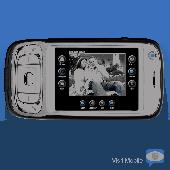
Share your surroundings and talk face-to-face from anywhere using your Mobile phone. iVisit Mobile lets you transmit and receive live video from your Mobile phone to show friends and family where you are or attend a business meeting without being tethered to your desk. iVisit Mobiles features multiparty video conferencing with up to 8 users, push-to-talk audio calls,...
Category: Internet / Dial-up & Connectivity
Publisher: iVisit LLC, License: Commercial, Price: USD $0.00, File Size: 2.2 MB
Platform: Unknown
Portable GPS Navigation toolbar for Internet Explorer.
Portable Gps Navigation toolbar for Internet Explorer. Find portable Gps units for your car, truck or minvan from top name brands including Tom Tom, Magellan and Garmin. Discover the world of eBay and shop for portable Gps navigation systems directly from your browser toolbar.
Category: Internet / Browsers
Publisher: Portable GPS Navigation System, License: Freeware, Price: USD $0.00, File Size: 1.1 MB
Platform: Windows
Demo
ZylGPSReceiver is a Delphi/CBuilder component that communicates with a serial Gps receiver. It returns latitude, longitude, Altitude, speed, heading and many other parameters of the position. This component works with any NMEA compatible receiver connected to one of the serial ports. You can use it also with USB and Bloototh devices, because these devices usually have a...
Category: Software Development / Components: Delphi
Publisher: Zyl Soft, License: Demo, Price: USD $129.99, File Size: 1.7 MB
Platform: Windows
The five essential benefits:
PLAN ROUTES - Use real colour maps on a PC, Pocket PC or Smartphone to help you find your way. Simply click on the map to plan your route and see leg distance, compass bearing, journey length and estimated trip time. You can even visualise your routes in a continuous 3D landscape.
PRINT MAPS - Create and print full colour...
Category: Home & Education / Miscellaneous
Publisher: Memory-Map, Inc., License: Shareware, Price: USD $0.00, File Size: 18.6 MB
Platform: Windows
Shareware
ZylGPSReceiverAX is an an award-winning ActiveX control that communicates with a serial Gps receiver. It returns latitude, longitude, Altitude, speed, heading and many other parameters of the position. This control works with any NMEA compatible receiver connected to one of the serial ports. You can use it also with USB devices, because these devices usually have a driver...
Category: Software Development / ActiveX
Publisher: Zyl Soft, License: Shareware, Price: USD $99.99, File Size: 863.4 KB
Platform: Windows
Nokia Map Manager is a program that allows you to manage and transfer GPS maps to mobile phone.
Nokia Map Manager is a program that allows you to manage and transfer Gps maps to Mobile phone. The Map Manager is for the 6110 Navigator only. The program is provided with scan function to search maps on the computer and DVD. Nokia Map Manager is an additional application and is used together with Nokia PC Suite 6.86 and later versions.
Nokia Map Manager helps you to manage...
Category: Internet / Communications
Publisher: Nokia, License: Freeware, Price: USD $0.00, File Size: 0
Platform: Windows
Serial Splitter Mobile by Eltima for Windows Mobile 2003/2005 operating systems is a new generation of professional system utilities for Mobile devices. This is the software for splitting real serial ports into virtual ones. It can be useful if you need several applications to work with the same serial port on your Mobile device simultaneously. Finally, one...
Category: Utilities
Publisher: ELTIMA Software GmbH, License: Shareware, Price: USD $49.95, File Size: 147.0 KB
Platform: Unknown
Shareware
Gps Mapping Software for Windows, Loading topographic maps, manage Gps devices and more. The software can be used with various map formats including: GeoTiff, BSB Nautical Charts, AutoCad DXF files, ESRI Shapefiles. Using calibration you can also use scanned or downloaded JPG, BMP, GIF, PNG and TIF maps. The software can be used for survey, research, track and trace, real...
Category: Home & Education / Science
Publisher: Eye4Software B.V., License: Shareware, Price: USD $75.04, EUR49, File Size: 6.7 MB
Platform: Windows

Improve your golf game with a handheld Gps that gives distance to pin, club suggestions, locations of hazards and much more. Wherever in the world you play golf, the sureshotgps will allow you to obtain distances from tee to green. Experience the difference with better club selection, speedier play and statistical information per round of golf. The sureshotgps relies on Gps...
Category: Home & Education
Publisher: Absolute Software Pty Ltd, License: Shareware, Price: USD $399.00, File Size: 3.8 MB
Platform: Windows
Use your gps enabled mobile phone (WM5 / WM6) to store your position to a file and/or the internet.
Use your Gps enabled Mobile phone (WM5 / WM6) to store your position to a file and/or the internet.Together with the website www.mapwm.com you can use MapWM to generate Google Earth/Map output and GPX files. You may configure the software to store in regular intervals or to perform smart save and store only important track points. Audible speed warning: prevent speeding ticket,...
Category: Home & Education / Genealogy
Publisher: Seiz System Engineering, License: Freeware, Price: USD $0.00, File Size: 314.0 KB
Platform: Unknown