Free Downloads: Area Calculator Excel Gps Coordinates

Gps/J is a console for all Bluetooth-enabled Gps receivers (now with 20000 European towns and cities!), a mobile navigation tool for cellular phone owners and the most affordable and convenient way to use location services.
It is a J2ME application for JSR82-compliant devices, which means "devices with a programmable Bluetooth interface".
Saying...
Category: Home & Education / Miscellaneous
Publisher: GPS/J Project, License: Demo, Price: USD $0.00, File Size: 281.0 KB
Platform: Windows
IInnerSoft CAD is a plug-in for AutoCAD that installs a set of productivity tools for Civil and Survey engineering, Counting, Estimating and measurements in construction project budgets.
You can:
-Export to an Excel Sheet the values of Area/Length property or Coordinates for various AutoCAD entities.
-Import from an Excel Sheet the...
Category: Multimedia & Design / Image Editing
Publisher: InnerSoft, License: Shareware, Price: USD $70.00, File Size: 2.2 MB
Platform: Windows
A.C. Calculator examines a plan view of your model in Windows bitmap format (.BMP) and calculates the Area and an approximation of the A.C. location of the colored parts in the image. Also useful for evaluation of other shape parameters, like frontal Area of a car.
Category: Business & Finance / Calculators
Publisher: MH AeroTools, License: Freeware, Price: USD $0.00, File Size: 1.9 MB
Platform: Windows
Have a Gps and a laptop? Use this to find your way. Make patterns or a trail to share with others. When the application starts, you may pick your Area of operations - be it North America, South America, Europe and Asia, or Australia. Your quadrant is determined by where you are in relation to the Equator and the Prime Meridian. Tracking of your position is automatically enabled...
Category: Home & Education / Miscellaneous
Publisher: LogicAll Solutions, LLC, License: Freeware, Price: USD $0.00, File Size: 4.6 MB
Platform: Windows
InnerSoft CAD is a add-on for AutoCAD.
InnerSoft CAD is a add-on for AutoCAD. This group of tools will allows you to: Export to a Excel Sheet the values of Area/Length property or Coordinates for various AutoCAD entities. Import from a Excel Sheet the vertex Coordinates for a set of 2D polylines or 3D polylines (you can choose between 3 different methods). You can also import a set of points from...
Category: Multimedia & Design / Multimedia App's
Publisher: InnerSoft, License: Demo, Price: USD $70.00, File Size: 987.0 KB
Platform: Windows
InnerSoft CAD is an add-on for AutoCAD that installs a set of productivity tools for Civil and Survey, Counting, Estimating and measurements in construction project budgets.
You can:
- Export to a Excel Sheet the values of Area/Length property or Coordinates for various AutoCAD entities.
- Import from an Excel Sheet the vertex Coordinates for...
Category: Multimedia & Design / Image Editing
Publisher: InnerSoft, License: Shareware, Price: USD $70.00, File Size: 3.9 MB
Platform: Windows
FREE GPS Software for your Garmin, Magellan or Lowrance GPS.
FREE Gps Software for your Garmin, Magellan or Lowrance Gps.
EasyGPS is the fast and easy way to upload and download waypoints, routes, and tracks between your Windows computer and your Garmin, Magellan, or Lowrance Gps. EasyGPS lists all of your waypoints on the left side of the screen, and shows a plot of your Gps data on the right. Use EasyGPS to back up...
Category: Internet / Communications
Publisher: TopoGrafix, License: Freeware, Price: USD $0.00, File Size: 3.9 MB
Platform: Windows
Excel Area Code Lookup Software is an application that allows you to convert Area codes to city and state names in one or more Microsoft Excel files. You can add a single or multiple Excel documents and also apply changes to a specific block of cells, the active sheet, or an entire workbook.
Category: Business & Finance / MS Office Addons
Publisher: Sobolsoft, License: Shareware, Price: USD $19.99, File Size: 2.7 MB
Platform: Windows
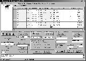
The program produces a set with seven parameters of the sapatial Helmert transformation valid for an specific Area, with which then arbitrary Coordinates of the Area can be transformed from one reference system into another with high accuracy. The seven transformation parameters are computed with a set of individual identical points. Those are points with known...
Category: Business & Finance / Calculators
Publisher: Killet Softwareentwicklung GbR, License: Shareware, Price: USD $170.00, File Size: 1.8 MB
Platform: Windows
My Gps Logger 1.01 is a program designed to be used with My Fuel Tax 4.0. With My Gps Logger you can log all the locations where your truck has been to a monthly data file. This data file can later be imported into My Fuel Tax 4.0 by calculating the miles in state using Microsoftâ Mappoint. This is what you will need to use My Gps Logger with My Fuel Tax:a laptop with...
Category: Home & Education / Miscellaneous
Publisher: Spinnaker Software Solutions, License: Freeware, Price: USD $0.00, File Size: 477.7 KB
Platform: Windows
Cartesian Coordinates, spherical Coordinates und cylindrical Coordinates can be transformed into each other. (5 languages, 2 and 3 dimensions)
Category: Home & Education / Miscellaneous
Publisher: Greuer Andreas, License: Shareware, Price: USD $11.00, File Size: 993.3 KB
Platform: Windows

InnerSoft CAD is a add-on for AutoCAD.
InnerSoft CAD is a add-on for AutoCAD. This group of tools will allows you to: Export to a Excel Sheet the values of Area/Length property or Coordinates for various AutoCAD entities. Import from a Excel Sheet the vertex Coordinates for a set of 2D polylines or 3D polylines (you can choose between 3 different methods). You can also import a set of points from...
Category: Multimedia & Design / Multimedia App's
Publisher: InnerSoft, License: Demo, Price: USD $70.00, File Size: 1.4 MB
Platform: Windows

TRANSDATpro can prove a helpful tool for professionals, providing them with the possibility to perform coordinate transformations fast and easy by use of the coordinate reference systems of their choice. TRANSDATpro performs Coordinate Transformations fast and with high accuracy. The coordinate conversion software supports worldwide thousands of Coordinate Systems, geodetic Reference Systems...
Category: Home & Education / Science
Publisher: Killet GeoSoftware Ing.-GbR, License: Shareware, Price: USD $270.00, EUR240, File Size: 5.3 MB
Platform: Windows
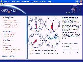
Develop precise, efficient, and reliable Gps software in record time with this multithreaded component for desktop and mobile devices, including PocketPC, Windows CE, Tablet PC, Smartphone and now Windows Mobile! Over fifty classes in one lightweight assembly give you unparalleled features while saving you hundreds of dollars in Gps device testing. Gps.NET is loaded...
Category: Software Development
Publisher: GeoFrameworks, LLC, License: Commercial, Price: USD $199.00, File Size: 8.5 MB
Platform: Windows,
VisualGPSXP is a general purpose utility for monitoring the output of a GPS receiver.
VisualGPSXP is a general purpose utility for monitoring the output of a Gps receiver. Using the NMEA data from the Gps receiver, VisualGPSXP will display various statuses graphically.
Tools such as a survey utility average the position and shows accuracy of the Gps receiver in a static application.
Main features:
- Multiple connection...
Category: Home & Education / Miscellaneous
Publisher: VisualGPC, License: Shareware, Price: USD $25.00, File Size: 1.1 MB
Platform: Windows
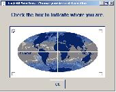
Have a Gps and a laptop? Use this to find your way. Make patterns or a trail to share with others. When the application starts, you may pick your Area of operations - be it North America, South America, Europe and Asia, or Australia. Your quadrant is determined by where you are in relation to the Equator and the Prime Meridian. Tracking of your position is automatically enabled...
Category: Home & Education / Miscellaneous
Publisher: LogicAll Solutions, LLC, License: Freeware, Price: USD $0.00, File Size: 4.6 MB
Platform: Windows

Gps Navigator with using a scanned maps and possibility to open a lot of maps together. - you can show a current Gps data (Speed, Direction, Longitude, Latitude, Time, Date, Height); - you can open any of scanned maps (in a "bmp" or "dib" format); - you can calibrate the scanned maps yourself by two calibration points only (left-top and right-bottom); - calibrations are...
Category: Home & Education
Publisher: Valeri Vlassov, License: Demo, Price: USD $19.00, File Size: 4.6 MB
Platform: Windows
 Demo
Demo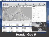
HoudahGeo is a photo geocoding and geotagging tool for Mac. Use HoudahGeo to attach Gps Coordinates and location names to your photos. HoudahGeo writes EXIF and XMP geotags to JPEG and RAW image files. This creates a permanent record of where a photo was taken. Just like a Gps-enabled camera. HoudahGeo is the only application that can both write future-proof...
Category: Multimedia & Design / Media Catalogers
Publisher: Houdah Software s.à r.l, License: Demo, Price: USD $39.00, File Size: 22.9 MB
Platform: Mac
Shareware
Virtual Gps is a Gps simulator software. You can use it to simulate a Gps receiver unit connected to your system. It's ideal when you need Gps input, but you have no signal or for development purposes. It supports various NMEA sentences, so it can be used with any Gps mapping software. You can use it using a null-modem cable connected to two physical serial...
Category: Internet / RSS & Web Blog Tools
Publisher: Zyl Soft, License: Shareware, Price: USD $39.99, File Size: 856.0 KB
Platform: Windows
The calculator has been developed as an aid for AO-40 users.
The Calculator has been developed as an aid for AO-40 users. It was done in Microsoft Excel which must be installed in your PC. In tools and options window of Excel you can set a form which looks like in the following figures. All the frequencies are in MHz but the BRX display and RX display are put separately in MHz and kHz (4 digits without decimal point) for practical...
Category: Business & Finance / Applications
Publisher: OK2AQK, License: Freeware, Price: USD $0.00, File Size: 598.8 KB
Platform: Windows
The program accepts NMEA GPS sentences from most GPS receivers that connect to a USB port.
The program accepts NMEA Gps sentences from most Gps receivers that connect to a USB port.
The program can display satellite images of waypoint locations on the track plotter.
Is a free software for recording , monitoring and plotting Gps data, very useful and very easy.
Category: Home & Education / Miscellaneous
Publisher: Club Cruceros de La Paz A.C., License: Freeware, Price: USD $0.00, File Size: 10.6 MB
Platform: Windows
Golf GPS Devices toolbar for internet explorer.
Golf Gps Devices toolbar for internet explorer. Find golf Gps devices are great bargain prices. We have all the latest golf Gps devices for sale both new and used. Whether you're looking for the iGolf, Golf Buddy, GolfLogix, SonoCaddie, or SkyCaddie, you can find it here along with their accessories. We are always searching our networks to bring you the best deals on golf...
Category: Internet / Browsers
Publisher: Golf GPS Devices, License: Freeware, Price: USD $0.00, File Size: 1.1 MB
Platform: Windows