Free Downloads: Conversion Raster Maps To Vector Maps
 Shareware
Google Maps Terrain Downloader is a tool that can automatically download the google terrain Maps images to your PC. It can download the small tiles and save them to your hard disk. After downloading, you can view the Maps offline by its tool Maps Viewer, or you can combine the small images into one big map image. If you want to make a map...
Category: Internet / Download Managers
Publisher: allmapsoft.com, License: Shareware, Price: USD $29.99, File Size: 305.3 MB
Platform: Windows
think! Bubble Maps is a Windows tool for creating bubble Maps and capturing your thought. Using simple mouse click, drags and typing, your thoughts get put to paper (virtual), quickly and effectively.
The key feature of think! Bubble Maps is speed which makes it an excellent tool for live capture. You can use this program during meetings,...
Category: Multimedia & Design / Multimedia App's
Publisher: Lowrie Associates Ltd, License: Shareware, Price: USD $41.90, File Size: 5.9 MB
Platform: Windows
Shareware
VeryDOC Bitmap to PS Vector Converter uses advanced algorithms to calculate the paths of Raster patterns and convert Raster patterns to Vector ones.It is a key component for many professional,commercial,industrial and scientific activity. Features of Bitmap to PS Vector Converter: 1.Support Microsoft Windows 2000 and later systems of both 32 and 64-bit....
Category: Business & Finance / Business Finance
Publisher: VeryDOC.com Inc, License: Shareware, Price: USD $299.00, AED100, File Size: 2.4 MB
Platform: Windows
MapComp is a powerful and free Windows Software for drawing images of linkage Maps and to compare linkage Maps and indicate common markers.
MapInspect can display, print and save images, and has no limit to the number of Maps it can compare (but only neighbouring Maps are compared). Maps can be flipped within...
Category: Multimedia & Design / Multimedia App's
Publisher: MapInspect, License: Freeware, Price: USD $0.00, File Size: 616.7 KB
Platform: Windows
Shareware
VeryDOC JPG to EPS Vector Converter uses advanced algorithms to calculate the paths of Raster patterns and convert Raster patterns to Vector ones.It is a key component for many professional,commercial,industrial and scientific activity. Features of JPG to EPS Vector Converter: 1.Support Microsoft Windows 2000 and later systems of both 32 and 64-bit....
Category: Business & Finance / Business Finance
Publisher: VeryDOC.com Inc, License: Shareware, Price: USD $299.00, AED100, File Size: 2.4 MB
Platform: Windows
This software development kit (SDK) provides the binaries and programming reference for the Bing Maps Silverlight Control. You can use this control to build your own web sites that use Bing Maps.
The Bing Maps Silverlight Control combines the power of Silverlight and Bing Maps to provide an enhanced mapping experience....
Category: Utilities / Misc. Utilities
Publisher: Microsoft, License: Freeware, Price: USD $0.00, File Size: 3.8 MB
Platform: Windows

OkMap is a GPS and map software that:
-Works with vectorial Maps and calibrates Raster Maps
-Organizes paths by creating waypoints, routes and tracks
-Uploads/downloads data to/from your GPS
-Uses altitude DEM data
-Supports GPS real-time navigation
-Sends/receives vehicles position and display tracks on Maps in real...
Category: Business & Finance / Applications
Publisher: Gian Paolo Saliola, License: Freeware, Price: USD $0.00, File Size: 20.2 MB
Platform: Windows
Shareware
VeryDOC GIF to Vector Converter uses advanced algorithms to calculate the paths of Raster patterns and convert Raster patterns to Vector ones.It is a key component for many professional,commercial,industrial and scientific activity. Features of GIF to Vector Converter: 1.Support Microsoft Windows 2000 and later systems of both 32 and 64-bit. 2.Set...
Category: Business & Finance / Business Finance
Publisher: VeryDOC.com Inc, License: Shareware, Price: USD $299.00, AED100, File Size: 2.4 MB
Platform: Windows
Shareware
VeryDOC JPG to Vector Converter uses advanced algorithms to calculate the paths of Raster patterns and convert Raster patterns to Vector ones.It is a key component for many professional,commercial,industrial and scientific activity. Features of JPG to Vector Converter: 1.Support Microsoft Windows 2000 and later systems of both 32 and 64-bit. 2.Set...
Category: Business & Finance / Business Finance
Publisher: VeryDOC.com Inc, License: Shareware, Price: USD $299.00, AED100, File Size: 2.4 MB
Platform: Windows
Shareware
VeryDOC Bitmap to Vector Converter uses advanced algorithms to calculate the paths of Raster patterns and convert Raster patterns to Vector ones.It is a key component for many professional,commercial,industrial and scientific activity. Features of Bitmap to Vector Converter: 1.Support Microsoft Windows 2000 and later systems of both 32 and 64-bit....
Category: Business & Finance / Business Finance
Publisher: VeryDOC.com Inc, License: Shareware, Price: USD $299.00, AED100, File Size: 2.4 MB
Platform: Windows
Shareware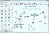
Create network maps with this powerful network diagrammer. Draw a LAN topology.
10-Strike Network Diagram is a powerful network diagrammer and mapper for the quick creation of visual local-area network Maps and diagrams, and exporting them to Microsoft Visio, or saving as charts, Vector, or Raster images. The program will scan your managed switches via SNMP and discover the LAN topology automatically. It supports scanning via the ICMP, TCP,...
Category: Software Development / Databases & Networks
Publisher: 10-Strike Software, License: Shareware, Price: USD $149.95, RUB3990, File Size: 5.3 MB
Platform: Windows
PlanetGIS Explorer is a free viewer for PlanetGIS maps and GIS exchange files.
PlanetGIS Explorer is a free viewer for PlanetGIS Maps and GIS exchange files. PlanetGIS Explorer allows you to navigate through Maps, query map elements and view attribute information from linked database tables. Also PlanetGIS Explorer allows you to customize the appearance of Maps for purposes of creating hardcopy printouts, but does not allow you to...
Category: Multimedia & Design / Graphics Viewers
Publisher: Planet GIS, License: Freeware, Price: USD $0.00, File Size: 5.4 MB
Platform: Windows
If you want to edit a Raster file in your CAD program, you first have to convert it to a Vector file. AbleTracer does just that, transforming scanned paper drawings into a Vector format. It looks like a typical graphics program, with toolbars and floating palettes, you can edit Raster image, vectorize it and edit the Vector drawing. AbleTracer also offers...
Category: Multimedia & Design / Image Editing
Publisher: AbleTracer Development, License: Shareware, Price: USD $79.95, EUR57.11, File Size: 2.4 MB
Platform: Windows
Shareware
FPS Maps for WPF is a brand new component with a set of built-in country Maps. There are 15 Inbuilt Countries. FPS Maps for WPF contains samples of how to work with it and customize. Maps navigation can be performed via Navigation bar which supports Themes and mouse. You can pan with mouse or zoom in/out with mouse scroll. More options...
Category: Software Development / Components & Libraries
Publisher: FPS Components, License: Shareware, Price: USD $199.00, File Size: 1.1 MB
Platform: Windows
With yalips maps you get 4 products in 1.
With yalips Maps you get 4 products in 1. You are more productive, more creative and perform better on your job when using visual software tools. With the resulting visualizations you can communicate more effectively and convincingly to your collegues, your boss, your customer or the chairman of the board. Therefore many companies spent a lot of money on such tools. Unfortunately,...
Category: Business & Finance / Project Management
Publisher: yalips Software, License: Shareware, Price: USD $80.00, File Size: 29.6 MB
Platform: Windows
RxSpotlight for Windows is the next generation of raster and hybrid editing software.
RxSpotlight for Windows is the next generation of Raster and hybrid editing software. Today most drawing information is stored on paper or aperture cards. By using scanning technology in combination with RxSpotlight for Windows, you can edit your drawings directly without having to convert them to a CAD format. RxSpotlight for Windows is an advanced program for Raster,...
Category: Multimedia & Design / Digital Media Editors
Publisher: Rasterex, License: Shareware, Price: USD $4302.35, File Size: 66.1 MB
Platform: Windows
This program is a tool for stretching a bitmap image (a Raster image), trimming it to a box, and calibrating it. This is primarily of use when dealing with a scanned image of a paper map. Often when making a scan it is hard to get the image precisely aligned; sometimes with old Maps the paper has stretched. It can be useful where you want to make a tiled map from a number...
Category: Multimedia & Design / Multimedia App's
Publisher: Map Library, License: Freeware, Price: USD $0.00, File Size: 755.8 KB
Platform: Windows

Commercial realtors require accurate and reliable tools to publish available properties online and show them on the website (specifying region, county, state, and city). We have created a unique Interactive Real Estate Map with all USA states and counties on it for real estate business. USA Real Estate Map is a unique and amazing Vector-based tool that is very simple to use. We...
Category: Internet
Publisher: USFlashMap.com, License: Shareware, Price: USD $399.00, File Size: 3.9 MB
Platform: Windows, Mac, Linux, Unix, MS-DOS, AS/400, OS/2
TopoGun is a stand-alone resurfacing, and maps baking application.
TopoGun is a stand-alone resurfacing, and Maps baking application. The resurfacing functions in TopoGun will help you modify and/or recreate the edgeflow of your digital 3D models.
The Maps baking functions, will help you bake various types of texture Maps from your high resolution 3D models and then allow you to apply them to your newly...
Category: Multimedia & Design / Animation
Publisher: SC PIXELMACHINE SRL, License: Shareware, Price: USD $100.00, File Size: 55.5 MB
Platform: Windows
You can create a backup of your maps with JaVaWa GMTK and restore these (e.
You can create a backup of your Maps with JaVaWa GMTK and restore these (e.g. on another computer) including unlock codes. Re-installing Maps is unnecessary.
Migration of your Garmin Maps from and old computer to a new one is straightforward with this application.
Category: Utilities / Backup
Publisher: JaVaWa GPS-tools, License: Shareware, Price: USD $0.00, File Size: 5.4 MB
Platform: Windows
Raster Effects is a plugin for Adobe Illustrator which creates high quality Raster images from Illustrator's Vector geometry. Renderings are based on smooth spline Vector geometry created in Illustrator, and rendered anti aliased to a high definition image suitable for print or web applications.
Category: Multimedia & Design / Multimedia App's
Publisher: Mission Software, License: Shareware, Price: USD $49.95, File Size: 2.2 MB
Platform: Windows
Shareware
Vectorize your images into scalable and clear art! Auto Vector converts photographs and images into scalable Vector files. Vector-based graphics appear smooth at any size or resolution. Auto Vector does the Conversion automatically, you don't need to do any manual tracing. Just load an image, set the level of details globally and (optionally) locally and the...
Category: Multimedia & Design / Image Editing
Publisher: Caricature Software, License: Shareware, Price: USD $49.95, File Size: 2.1 MB
Platform: Windows
Live Satellite Maps or Google maps is a web server mapping applications.
Live Satellite Maps or Google Maps is a web server mapping applications.Provides scrolling map images and satellite photos around the earth and even the route between different places.Since 6 October 2005, live satellite Maps is part of local Google.Google live satellite Map provides the ability to zoom in or zoom out to show the map.The user can...
Category: Home & Education / Science
Publisher: www.satelliteview-of-my-house.com, License: Freeware, Price: USD $0.00, File Size: 643.0 KB
Platform: Windows
Shareware
GPS Mapping Software for Windows, Loading topographic Maps, realtime navigation, track recording, manage GPS devices and more. The software can be used with various map formats including: GeoTiff, BSB Nautical Charts, AutoCad DXF files, ESRI Shapefiles. Using calibration you can also use scanned or downloaded JPG, BMP, GIF, PNG and TIF Maps. The software can be used...
Category: Home & Education / Science
Publisher: Eye4Software B.V., License: Shareware, Price: USD $149.00, EUR99, File Size: 11.1 MB
Platform: Windows
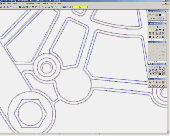
Image Trace is a raster to vector file format automatic conversion vectorization software.
Image Trace is a Raster to Vector file format automatic Conversion vectorization software. - Support center line and outline trace mode.- Support bmp input Raster file format.- Support dxf output Vector file format.- Generate arc segments and polyline segments for output result.- Adjust segment fluctuation and straightering parameter.- Support horizontal and...
Category: Multimedia & Design / Authoring Tools
Publisher: Cheewoo Engineering, License: Shareware, Price: USD $49.95, File Size: 4.0 MB
Platform: Windows