Free Downloads: Jpeg Metadata Gps
GPS Tuner was first launched in 2003.
Gps Tuner was first launched in 2003. Success followed introduction shortly. Over the years it became a best-selling favourite Gps software among off-roaders as a reliable, versatile feature-packed application suiting the needs of outdoor enthusiasts and professional off-road users alike. After five years of continuous development of previous Gps Tuner versions Gps...
Category: Web Authoring / Web Design Utilities
Publisher: GPS Tuner Ltd., License: Freeware, Price: USD $0.00, File Size: 4.5 MB
Platform: Windows
The Gps Detector software is used to update the Gps detector's database , updating maps , routes and camera locations . The device itself is based on pre-installed Gps coordinates, the device can indicate various road hazards like: Fixed cameras, Red light speed cameras and bus lane cameras, Usual speed measurement places and dangerous zones.
Category: Business & Finance / Business Finance
Publisher: Euro Noliker Kft., License: Freeware, Price: USD $0.00, File Size: 5.5 MB
Platform: Windows

X360 Exif & Tiff Tag Viewer ActiveX Control helps application developers to get all embed image information including EXIF tags, TIFF tags and Gps tags. It allows you to write useful information back to Jpeg, Png and Tiff image. Also, you can use it as a simply image viewer ActiveX with many useful viewing functions such as flip, move, print, rotate, zoom-in and zoom-out image....
Category: Software Development
Publisher: X360 Software, License: Shareware, Price: USD $49.90, File Size: 1.6 MB
Platform: Windows
The JPG Edit EXIF Data In Multiple Files application was designed to help you change Metadata in one or many JPG / Jpeg files. JPG Edit EXIF Data In Multiple Files helps you to change Metadata in one or many JPG/Jpeg files. Image files could be upload by one single or ain a folder
Category: Multimedia & Design / Media Management
Publisher: Sobolsoft, License: Shareware, Price: USD $0.00, File Size: 4.7 MB
Platform: Windows
The Gps Controller software is a free program designed to allow you to configure a range of Gps receivers. There are versions that run on Windows desktop computers, or Windows Mobile devices.
Before downloading the software, it recommend downloading and reading the documentation to confirm which version you need.
Category: Home & Education / Miscellaneous
Publisher: Trimble Navigation, License: Freeware, Price: USD $0.00, File Size: 30.9 MB
Platform: Windows
Description explorer is a collection of tools for Metadata and file management for Windows operating systems.
Main features:
- New Version 0.5.2 released, this version contains major bugfixes that makes the overall software much more stable.
- Easily classify and search multimedia files (pictures, audio files, etc.).
- Create reports...
Category: Business & Finance / Business Finance
Publisher: Optima SC Inc., License: Shareware, Price: USD $35.00, File Size: 10.8 MB
Platform: Windows
GPS-CCD:is a novel computational program for the
Prediction of Calpain Cleavage Sites.
Gps-CCD:is a novel computational program for the
Prediction of Calpain Cleavage Sites.
The online service and local packages of Gps-CCD 1.0 were
implemented in JAVA/. For the online service, we tested the Gps-CCD1.0 on a variety of internet browsers, including Internet Explorer 6.0, Netscape Browser 8.1.3 and Firefox 2 under the Windows XPOperating System...
Category: Web Authoring / JavaScript
Publisher: The CUCKOO Workgroup, License: Freeware, Price: USD $0.00, File Size: 19.2 MB
Platform: Windows
Windows Explorer is not the easiest thing to use. It only shows the files of one folder at a time, and with only limited information (and sometimes, the dates shown are misleading). It's also not the swiftest way to search through your files, or data you have just received. Imagine being able to copy file information together with additional file properties into a self-contained table (Excel...
Category: Utilities / File & Disk Management
Publisher: Filecats Limited, License: Shareware, Price: USD $49.99, File Size: 5.9 MB
Platform: Windows
ThinkVantage Gps (Global Positioning System) receives signals from the Gps satellites and determines the location of your ThinkPad. This program is easy to install and easy to manipulate.
This package installs the software (Gps driver) to enable the following devices:
- Ericsson F3507g
- Ericsson F3607gw
- Ericsson F5521gw
-...
Category: Utilities / System Utilities
Publisher: Lenovo, License: Freeware, Price: USD $0.00, File Size: 20.6 MB
Platform: Windows
The OSTN02 extension for ArcPad is a FREE tool that automatically transforms Gps data and aligns it with Ordnance Survey (OS) background map. This easy-to-use extension removes the need to manually post-process Gps data by providing’ on the fly’ transformation of WGS84 latitude and longitude into OSTN02 corrected British National Grid coordinate. Data capture using...
Category: Home & Education / Miscellaneous
Publisher: ESRI (UK) Ltd, License: Freeware, Price: USD $0.00, File Size: 8.0 MB
Platform: Windows

Overview Gps Simulator is software that generates a virtual Gps data Used to develop and simulation of Gps applications -Save testing and development time -No location restriction or work everywhere -No Gps device needed Feature Easy routing Selectable map(7EA Map) Support speed control Support 10EA NMEA protocol messages(GGA, GNS, GLL, RMC, VTG,...
Category: Desktop Enhancements / Shell & Desktop Managers
Publisher: NMEAsoft, License: Demo, Price: USD $150.00, File Size: 3.3 MB
Platform: Windows
Have a Gps and a laptop? Use this to find your way. Make patterns or a trail to share with others. When the application starts, you may pick your area of operations - be it North America, South America, Europe and Asia, or Australia. Your quadrant is determined by where you are in relation to the Equator and the Prime Meridian. Tracking of your position is automatically enabled when the...
Category: Home & Education / Miscellaneous
Publisher: LogicAll Solutions, LLC, License: Freeware, Price: USD $0.00, File Size: 4.6 MB
Platform: Windows

Improve your golf game with a handheld Gps that gives distance to pin, club suggestions, locations of hazards and much more. Wherever in the world you play golf, the sureshotgps will allow you to obtain distances from tee to green. Experience the difference with better club selection, speedier play and statistical information per round of golf. The sureshotgps relies on Gps...
Category: Home & Education
Publisher: Absolute Software Pty Ltd, License: Shareware, Price: USD $399.00, File Size: 3.8 MB
Platform: Windows
Hidden Data Detector is a free tool that was designed to find and identify hidden data & Metadata in files. Hidden Data Detector can analyze Microsoft Office documents (Word, Excel, PowerPoint), OpenOffice.org / StarOffice documents, Jpeg, Jpeg 2000, PNG, and SVG image files, AVI and MP4 video files, and WAV and MP3 audio files. Hidden Data Detector alerts you if...
Category: Security & Privacy / Other
Publisher: Digital Confidence, License: Freeware, Price: USD $0.00, File Size: 543.5 KB
Platform: Windows
 Demo
Demo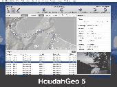
HoudahGeo is a photo geocoding and geotagging tool for Mac. Use HoudahGeo to attach Gps coordinates and location names to your photos. HoudahGeo writes EXIF and XMP geotags to Jpeg and RAW image files. This creates a permanent record of where a photo was taken. Just like a Gps-enabled camera. HoudahGeo is the only application that can both write future-proof...
Category: Multimedia & Design / Media Catalogers
Publisher: Houdah Software s.à r.l, License: Demo, Price: USD $39.00, File Size: 22.9 MB
Platform: Mac
GPSCAD Transfer is an application for transferring points between a gps device and autocad.
GPSCAD Transfer is an application for transferring points between a Gps device and autocad. The present version works with a Magellan Gps device, but the next release will also work with a Garmin Gps device. It allows you to convert latitude and longitude to utm zone nad 83 in either the US or in metric measurement system.
Category: Multimedia & Design / Image Editing
Publisher: Timberwolf Software Solutions, LLC, License: Shareware, Price: USD $0.00, File Size: 2.6 MB
Platform: Windows
GPS Send Map is a Windows interface program which uses (sendmap.
Gps Send Map is a Windows interface program which uses (sendmap.exe) to load the IMG maps to the Gps.This program works well and setup is easy, although there seams to be minor issues in some windows OS.The Gps acted as usual and my maps appeared on the screen as usual. NICE.
Category: Security & Privacy / Other
Publisher: DougsBrat, License: Freeware, Price: USD $0.00, File Size: 1.5 MB
Platform: Windows
The Metadata Browser is a web resource that uses HTML and SOAP calls to display entity Metadata more easily. By default it installs a link in the Settings section of CRM under Customization.
The Microsoft CRM 3.0 SDK includes a live Metadata browser. This replaces the static browser built into previous versions of the SDK.
Category: Software Development / Misc. Programming
Publisher: Microsoft, License: Freeware, Price: USD $0.00, File Size: 1.2 MB
Platform: Windows
Kinomap Gps File Fixer allows you to process some treatments on Gps file:
- convert almost any Gps file to standard NMEA 0183, compatible with Kinomap
- fill the gaps between points when your file is not 1Hertz: the extra point will be recreated by interpolation
- cut a long file in which there are loops of data (example: race) in several parts
Category: Home & Education / Miscellaneous
Publisher: ExcelLance, License: Freeware, Price: USD $0.00, File Size: 19.6 MB
Platform: Windows
Shareware
Gps Mapping Software for Windows, Loading topographic maps, realtime navigation, track recording, manage Gps devices and more. The software can be used with various map formats including: GeoTiff, BSB Nautical Charts, AutoCad DXF files, ESRI Shapefiles. Using calibration you can also use scanned or downloaded JPG, BMP, GIF, PNG and TIF maps. The software can be used for survey,...
Category: Home & Education / Science
Publisher: Eye4Software B.V., License: Shareware, Price: USD $149.00, EUR99, File Size: 11.1 MB
Platform: Windows
Keep track of discount Garmin GPS deals on with this Firefox toolbar.
Keep track of discount Garmin Gps deals on with this Firefox toolbar.compare and buy all the latest Garmin satellite navigation systems. If you want a discount Garmin Gps system this is the Firefox toolbar to use. We also provide information on the latest offers, price cuts and discount voucher codes to help you buy the latest Garmin Gps at the cheapest price possible in...
Category: Internet / Browsers
Publisher: Discount Garmin GPS, License: Freeware, Price: USD $0.00, File Size: 1.1 MB
Platform: Windows
Shareware
With AnyMP4 iPhone Gps Spoofer for Mac, you own one of the best Gps location spoofers for iOS devices. It lets you set the virtual Gps location within a few clicks. Whats more, you can play location-based games from anywhere in the world easily. Key Functions: 1. Fake yours iPhone location easily. AnyMP4 iPhone Gps Spoofer for Mac is an easy-to-use...
Category: Software Development
Publisher: AnyMP4 Studio, License: Shareware, Price: USD $9.96, File Size: 72.5 MB
Platform: Mac
An easy to use Gps downloading utility that lets you download your Gps waypoints easily and export them into a variety of formats useful for editing, display and importing into many different mapping programs.
Use Lobal to save Gps waypoints as:
- Text Files
- HTML Tables
- Shape Files
- Google Earth KML
- DBase Files.
Category: Utilities / Misc. Utilities
Publisher: Ecological Software Solutions, License: Freeware, Price: USD $0.00, File Size: 2.2 MB
Platform: Windows
Multicam or multiple video source capable webcam/video capture application with Gps filter support, and supports most codecs such as DivX, XViD, FFDShow, etc.
DSGPS.ax - Gps Video Overlay, a DirectShow filter which retrieves Gps and OBD-II data from XPort and/either/or XOBD, and imprints Gps speed, time, date, course, longitude, latitude, MPG, RPM, AIT,...
Category: Multimedia & Design / Video
Publisher: Curious Technology, License: Freeware, Price: USD $0.00, File Size: 78.9 KB
Platform: Windows
The fast track to GPS success.
The fast track to Gps success. The Linx MDEV-Gps-SR contains everything needed to rapidly evaluate the SR Series Gps modules and implement them in record time. This all-inclusive Master Development System features a pre-assembled development board with an on-board OLED display for standalone testing. The system can also be attached to a PC via USB and operated using the...
Category: Software Development / Misc. Programming
Publisher: Linx Technologies, Inc., License: Freeware, Price: USD $0.00, File Size: 98.5 MB
Platform: Windows