Free Downloads: Kml Evaluator
 Shareware
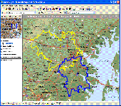
MPSuperShape is a shape manipulation tool for Microsoft MapPoint. MPSuperShape can be used to combine multiple shapes into one large shape, find the intersections (overlaps) between shapes, find boundary shapes around groups of pushpins, simplify shapes, delete multiple shapes, change shape colors, import/export shape files, and to create web pages. Import shape options include ESRI Shape (SHP)...
Category: Business & Finance / Business Finance
Publisher: Winwaed Software Technology LLC, License: Shareware, Price: USD $75.00, File Size: 13.6 MB
Platform: Windows
Janino is a compiler that reads a Java expression, block, or source file, and generates Java bytecode that is loaded and executed directly. It is not intended to be a development tool, but an embedded compiler for run-time compilation purposes, such as expression evaluators or "server pages" engines like JSP.
Properties
The major design goal was to keep the compiler...
Category: Software Development / Misc. Programming
Publisher: Arno Unkrig, License: Freeware, Price: USD $0.00, File Size: 104.0 KB
Platform: Windows, Linux, Mac
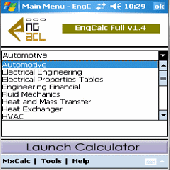
340+formulae catering to Mechanical Eng.
340+formulae catering to Mechanical Eng.,Hydraulic Eng.,Structural Eng.,Machine Design,Electrical Eng.,Fluid Mechanics,Heat and Mass Transfer,Thermodynamics, Pulp and Paper,HVAC,Heat Exchanger & Pipe Flow.FREE !!MxCalc (worth $4.99, embedded in the program) Unit Coverter - The most comprehensive unit converter utility tool. Comes with over 1000+ Units and 10000+ conversions. Can add more to...
Category: Utilities / System Utilities
Publisher: 3GR Technologies, License: Demo, Price: USD $49.99, File Size: 1.2 MB
Platform:
Shareware
The Advanced points manager imports points to AutoCAD drawing from different data sources. OLE-DB database, SHP (ESRI shape file), GPX (GPS eXchange format), Kml (Keyhole Markup Language), GML (Geography Markup Language), TXT, CSV. Additional options: savable configurations, point coordinate transformation from/to any world coordinate system, point can be ACAD point or ACAD block with...
Category: Business & Finance / Vertical Markets
Publisher: CADdicted inc., License: Shareware, Price: USD $119.00, File Size: 609.8 KB
Platform: Windows

TRANSDAT geosoftware executes coordinate transformations and geodetic datum shifts between many coordinate and reference systems of America, Australasia, Europe, Germany special and world-wide, with high precision and high speed: 1.The current and historical coordinate and reference systems of all countries of the European Union (EU) including the eastern extensions and the systems of non-EU...
Category: Home & Education / Science
Publisher: Killet Software Ing.-GbR, License: Shareware, Price: USD $170.00, EUR160, File Size: 4.4 MB
Platform: Windows
Live!Flight allows that everyone can track your flight in flight simulator in real-time, all over the world. Your aircraft is displayed as a 3D-model in a map of NASA World Wind.
For that purpose Live!Flight transmits position and flight attitude information. With a refreshing rate of 2 times per second you can see every aircraft's movement. A lot of more information like...
Category: Business & Finance / Business Finance
Publisher: Christoph Paulus, License: Shareware, Price: USD $29.00, File Size: 4.2 MB
Platform: Windows
90 formulae catering to Automotive Engineering. A must have for Engineers. Empower yourself with instant references and solutions of frequently encountered calculation at your finger tips. Just few taps, and all the calculations that consumed lots of efforts and time will vanish, there by increasing efficiency. This means you will have more time to analyze your information and make better...
Category: Business & Finance
Publisher: 3GR Technologies, License: Demo, Price: USD $29.99, File Size: 1.6 MB
Platform: Windows
ArBa3d is a 3D modeling software that allows to create a 3D model from a set of digital photos.
ArBa3d is a 3D modeling software that allows to create a 3D model from a set of digital photos. The tool takes as input a set of photos taken from different viewpoints. It tesselates the vertices and constraint edges from the user input to produce a 3D model that can then be exported to different 3D formats (vrml, obj, x, flt, x3d, Kml). The 3D models can also be displayed on the Web,...
Category: Multimedia & Design / Image Editing
Publisher: ArBa3d.com, License: Shareware, Price: USD $0.00, File Size: 5.3 MB
Platform: Windows
CoPilot Central is the desktop management software companion for CoPilot Live(Android and Windows Mobile). Buy additional map regions and other premium add-ons. Download maps for use with Android versions of CoPilot. Export trips to popular online mapping sites (using Kml format). Backup favorites and settings.
Category: Desktop Enhancements / Shell & Desktop Managers
Publisher: CoPilotLive, License: Freeware, Price: USD $0.00, File Size: 4.7 MB
Platform: Windows
The newest versions of ePubHub _require_ .
-Plain ASCII text files have the extension .txt
-Microsoft Word files have the extension .doc
-Adobe acrobat files have the extension .pdf
-Gemstar eBook files have the extension .prc
-Palm files have the extension .pdb or .prc
-Hiebook files have the extension .Kml
-Html files have the extension .html or .htm
-Adobe eBook files have the...
Category: Utilities / System Utilities
Publisher: ePubHub, License: Freeware, Price: USD $0.00, File Size: 483.5 KB
Platform: Windows

Geocode digital images with latitude, longitude, altitude, and direction information when collecting GIS field data. RoboGEO stamps this information onto the actual photo or writes it to the EXIF headers, allowing you to permanently geotag and link your photos to the GPS coordinates. All writing to the EXIF and IPTC headers is lossless and all of the existing comments (including the MakerNote...
Category: Multimedia & Design
Publisher: Pretek, Inc., License: Demo, Price: USD $34.95, File Size: 6.4 MB
Platform: Windows
The best open-source Wi-Fi scanning software – for Free!
The best open-source Wi-Fi scanning software – for Free!
With Inssider you can :
– Inspect your Wi-Fi and surrounding networks
– Scan and filter hundreds of nearby access points
– Troubleshoot competing access points and clogged Wi-Fi channels
– Highlight access points for areas with high Wi-Fi concentration
...
Category: Internet / Monitoring
Publisher: MetaGeek, LLC, License: Freeware, Price: USD $0.00, File Size: 1.7 MB
Platform: Windows
This utility scans exe or dll files of your choosing and detects usage of .
This utility scans exe or dll files of your choosing and detects usage of .NET types released by ESRI. It then generates a report of this usage for your review.
Among other things, you can use the information provided to verify that you are not using types from assemblies that require licenses beyond your target license level or to generate a list of types that you can compare...
Category: Utilities / Misc. Utilities
Publisher: Environmental Systems Research Institute, Inc., License: Freeware, Price: USD $0.00, File Size: 743.3 KB
Platform: Windows
Shareware
Manco Shapefile Editor is a powerful tool for creating and editing shapefiles, with easy, almost “on the flyâ€, geometry and data editing and possibility of direct creation of the shapefiles from the image files by image processing algorithms. This product is constantly developing and you will receive free updates just when they come. Since it’s only a start of the project,...
Category: Multimedia & Design / Image Editing
Publisher: Manco Software, License: Shareware, Price: USD $100.00, File Size: 6.1 MB
Platform: Windows
Shareware
Debugging stored MySQL functions and procedures has always been one of the primary concerns of MySQL database developers. Due to the unfortunate absence of generic debugging support in the MySQL DBMS, many developers are forced to resort to writing server side code on the client side to fill in this gap and obtain control over code execution. However, this approach is fundamentally incorrect,...
Category: Software Development / Databases & Networks
Publisher: MyDebugger.com, License: Shareware, Price: USD $99.00, File Size: 3.5 MB
Platform: Windows
Korti is a Google Earth plugin which allows you to see the unique 3D satellite map of Korti within your Google Earth application.
Korti provides you a detailed satellite imagery and geographic information about this geographic place.
To have Korti installed on your PC, first install for free Google Earth and then Korti 3D map plugin. After that, simply double click...
Category: Multimedia & Design / Multimedia App's
Publisher: Maplandia, License: Freeware, Price: USD $0.00, File Size: 309 B
Platform: Windows
Shape2Earth Globe lets you quickly and easily capture Google Earth images for your personal use.
Shape2Earth Globe lets you quickly and easily capture Google Earth images for your personal use. Capture images for use in popular applications like Microsoft Office and ESRI's ArcMap.
Shape2Earth Globe also saves the bounding box of the image in a Kml file. This data is then used to generate a world file and projection file so that your image can be loaded into a GIS, such...
Category: Multimedia & Design / Multimedia App's
Publisher: Shape2Earth, License: Freeware, Price: USD $0.00, File Size: 402.5 KB
Platform: Windows
CityCAD Viewer is an application for opening and exploring CityCAD models.
CityCAD Viewer is an application for opening and exploring CityCAD models. If you are a CityCAD user, this means you can share your models more easily with others.
CityCAD Viewer can be used to:
-Open, explore and save CityCAD models.
-Select elements within a CityCAD model and view information about them.
-Change the group or phase of elements in a city model.
...
Category: Multimedia & Design / Image Editing
Publisher: Holistic City, License: Shareware, Price: USD $0.00, File Size: 0
Platform: Windows

TRANSDATpro can prove a helpful tool for professionals, providing them with the possibility to perform coordinate transformations fast and easy by use of the coordinate reference systems of their choice. TRANSDATpro performs Coordinate Transformations fast and with high accuracy. The coordinate conversion software supports worldwide thousands of Coordinate Systems, geodetic Reference Systems...
Category: Home & Education / Science
Publisher: Killet GeoSoftware Ing.-GbR, License: Shareware, Price: USD $270.00, EUR240, File Size: 5.3 MB
Platform: Windows
With GeoIPTC you will be able to read the IPTC city information in pictures and get the corresponding coordinates to your photos from several free services and embed this into the pictures in standard tags in a very professional way. You will also create sets of pictures with all the metadata they contain including geographical tags as Kml or KMZ files for a quick view of the selection...
Category: Multimedia & Design / Media Catalogers
Publisher: SoftExperience, License: Shareware, Price: USD $112.00, File Size: 7.3 MB
Platform: Windows
Momentous HVAC Calculator.Scientific Evaluator - Superlative collection of Operators and instant reference to recent calculations. Memory functions etc.A must have for Engineers. This PocketPC software program empowers you with instant references and solutions of frequently encountered calculation at your finger tips. Just few taps, and all the calculations that consumed lots of efforts...
Category: Utilities / System Utilities
Publisher: 3GR Technologies, License: Demo, Price: USD $7.99, File Size: 2.9 MB
Platform: Windows,
Momentous HVAC Calculator.Scientific Evaluator - Superlative collection of Operators and instant reference to recent calculations. Memory functions etc.A must have for Engineers. This Palm software program empowers you with instant references and solutions of frequently encountered calculation at your finger tips. Just few taps, and all the calculations that consumed lots of efforts and...
Category: Utilities / System Utilities
Publisher: 3GR Technologies, License: Demo, Price: USD $7.99, File Size: 901.1 KB
Platform:
An easy to use GPS downloading utility that lets you download your GPS waypoints easily and export them into a variety of formats useful for editing, display and importing into many different mapping programs.
Use Lobal to save GPS waypoints as:
- Text Files
- HTML Tables
- Shape Files
- Google Earth Kml
- DBase Files.
Category: Utilities / Misc. Utilities
Publisher: Ecological Software Solutions, License: Freeware, Price: USD $0.00, File Size: 2.2 MB
Platform: Windows
Demo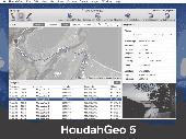
HoudahGeo is a photo geocoding and geotagging tool for Mac. Use HoudahGeo to attach GPS coordinates and location names to your photos. HoudahGeo writes EXIF and XMP geotags to JPEG and RAW image files. This creates a permanent record of where a photo was taken. Just like a GPS-enabled camera. HoudahGeo is the only application that can both write future-proof GPS tags to original images...
Category: Multimedia & Design / Media Catalogers
Publisher: Houdah Software s.à r.l, License: Demo, Price: USD $39.00, File Size: 22.9 MB
Platform: Mac
The CubicleSoftTM XLAuditorTM add-in for Microsoft Excel 2000/XP/2003 enables professionals to audit, understand, analyze, create, modify, compare, and debug any formula in any Excel spreadsheet.
If you use Excel frequently, you know about the F9 key and the built-in Excel Evaluator, but this tool is neither of those. Take a good look at the following screenshots to see how...
Category: Business & Finance / Applications
Publisher: CubicleSoft, License: Freeware, Price: USD $0.00, File Size: 1.1 MB
Platform: Windows