Free Downloads: Software County Maps
Harpwood County has a secret lake!
Harpwood County has a secret lake! Deep in the woods it makes up for its diminutive proportions with charming beauty. Now, using Carrara, you too can discover the delights of this hidden gem.
Features
- 1 Carrara Scene file (.CAR)
- 13 Carrara Objects (.CAR)
- 3 Grassy Clumps
- 3 Rocks
- 1 Jetty
- 2 Scattered Leaves
- 1 Reeds...
Category: Multimedia & Design / Multimedia App's
Publisher: DAZ Productions, Inc, License: Shareware, Price: USD $19.95, File Size: 2.7 MB
Platform: Windows
Enter all your tax lien (or deed) and county information into one easy-to-use database.
Enter all your tax lien (or deed) and County information into one easy-to-use database. From there, you will always be able to locate and track all your information on your tax lien investments.
You will also know how your portfolio is doing at any given time since the accrued interest and yield is automatically computed.
Category: Home & Education / Miscellaneous
Publisher: LandlordSoftware.com, License: Shareware, Price: USD $99.95, File Size: 37.6 MB
Platform: Windows
think! Bubble Maps is a Windows tool for creating bubble Maps and capturing your thought. Using simple mouse click, drags and typing, your thoughts get put to paper (virtual), quickly and effectively.
The key feature of think! Bubble Maps is speed which makes it an excellent tool for live capture. You can use this program during meetings, workshops, and seminars.
Category: Multimedia & Design / Multimedia App's
Publisher: Lowrie Associates Ltd, License: Shareware, Price: USD $41.90, File Size: 5.9 MB
Platform: Windows
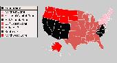
USA Real Estate Map Pro is a premium class Software for mapping: real estate properties, contact listings, offices and other geo spatial data. Interactive Real Estate map is rather simple to integrate with database listings: both to specify the states and counties that should be active on map, and pass the selected County name or ID back, for further use. Among the benefits of US...
Category: Business & Finance / Database Management
Publisher: USFlashMap.com, License: Shareware, Price: USD $399.00, File Size: 10.4 MB
Platform: Windows, Mac, Linux, Unix, MS-DOS, AS, 400
The WVLT Volunteer TV online station provides interactive weather Maps, regional radar weather information, State Radar, and an 8 Day Weather Forecast as well as State Satellite weather information, covering the communities of Tennessee and the wider region. This important coverage enables WVLT-TV to provide up to the minute severe weather alerts about tornados, hurricanes, flood, and...
Category: Home & Education / Miscellaneous
Publisher: BIA Information Network, License: Freeware, Price: USD $0.00, File Size: 0
Platform: Windows
Simple 2D first-person shooter set in County Tipperary in the Republic Of Ireland.
Simple 2D first-person shooter set in County Tipperary in the Republic Of Ireland. 3 levels. Shoot the aliens. Avoid getting shot. Do not shoot the aliens waving a white flag. Game also advertises the theft of an ancient, rare local artefact called a 'Sheela Na Gig', and asks for its return. Requires DirectX 9.0 to run.
Category: Games / Action
Publisher: T. O' Donnell Inc., License: Freeware, Price: USD $0.00, File Size: 1.6 MB
Platform: Windows
With yalips maps you get 4 products in 1.
With yalips Maps you get 4 products in 1. You are more productive, more creative and perform better on your job when using visual Software tools. With the resulting visualizations you can communicate more effectively and convincingly to your collegues, your boss, your customer or the chairman of the board. Therefore many companies spent a lot of money on such tools. Unfortunately,...
Category: Business & Finance / Project Management
Publisher: yalips Software, License: Shareware, Price: USD $80.00, File Size: 29.6 MB
Platform: Windows
Second Nature Software are recalling those we have lost, paying tribute to the heroic efforts of many and reminding themselves why this County is great. Please accept SNS invitation to download this special edition screen saver collection freely, as their gift, and feel free to share this page and Our America screen saver with friends and family. SNS think you'll find these...
Category: Desktop Enhancements / Screensavers
Publisher: Second Nature Software, Inc., License: Freeware, Price: USD $0.00, File Size: 3.4 MB
Platform: Windows
The database includes total of 17 data fields which consists of:
ZIP Code, Classification, Primary Record, City, City Alias Name, City Type, Mailing Name, State, State FIPS, Latitude, Longitude, Elevation, Area Code, County Name, County FIPS, Time Zone & Day Light Saving.
The complete database contains over 80,000 precise records. The sample database and the full...
Category: Web Authoring / Web Design Utilities
Publisher: IGEOCODE, License: Demo, Price: USD $25.95, File Size: 1.2 MB
Platform: Windows, Mac, Palm
Howard County Apartments
Category: Games / Puzzles
Publisher: Howard County Apartments, License: Freeware, Price: USD $0.00, File Size: 324.0 KB
Platform: Windows
PlanetGIS Explorer is a free viewer for PlanetGIS maps and GIS exchange files.
PlanetGIS Explorer is a free viewer for PlanetGIS Maps and GIS exchange files. PlanetGIS Explorer allows you to navigate through Maps, query map elements and view attribute information from linked database tables. Also PlanetGIS Explorer allows you to customize the appearance of Maps for purposes of creating hardcopy printouts, but does not allow you to save any changes to...
Category: Multimedia & Design / Graphics Viewers
Publisher: Planet GIS, License: Freeware, Price: USD $0.00, File Size: 5.4 MB
Platform: Windows
 Shareware
FPS Maps for WPF is a brand new component with a set of built-in country Maps. There are 15 Inbuilt Countries. FPS Maps for WPF contains samples of how to work with it and customize. Maps navigation can be performed via Navigation bar which supports Themes and mouse. You can pan with mouse or zoom in/out with mouse scroll. More options will be added in future...
Category: Software Development / Components & Libraries
Publisher: FPS Components, License: Shareware, Price: USD $199.00, File Size: 1.1 MB
Platform: Windows
Anychart is a flexible Macromedia Flash based-solution, which allows you to easily display any sort of data dealing with geographical locations. It contains United States Maps with Counties, World Map, etc. XML data file and a set of customizable options make AnyChart Maps a universal solution for web developers. AnyChart allows you to create superb, compact, interactive...
Category: Software Development
Publisher: AnyChart.Com, License: Shareware, Price: USD $199.00, File Size: 2.8 MB
Platform: Windows, Mac, Linux, Palm,
TopoGun is a stand-alone resurfacing, and maps baking application.
TopoGun is a stand-alone resurfacing, and Maps baking application. The resurfacing functions in TopoGun will help you modify and/or recreate the edgeflow of your digital 3D models.
The Maps baking functions, will help you bake various types of texture Maps from your high resolution 3D models and then allow you to apply them to your newly created optimized...
Category: Multimedia & Design / Animation
Publisher: SC PIXELMACHINE SRL, License: Shareware, Price: USD $100.00, File Size: 55.5 MB
Platform: Windows
MapCreator combines a cartography and a graphics programme.
MapCreator combines a cartography and a graphics programme. The Software is designed to create Maps and animated Maps of the highest quality as often required for presentations. For example, this could be Maps needed for a travel presentation. But also in
Category: Multimedia & Design
Publisher: primap.com, License: Freeware, Price: USD $0.00, File Size: 103.3 MB
Platform: Windows, Vista
You can create a backup of your maps with JaVaWa GMTK and restore these (e.
You can create a backup of your Maps with JaVaWa GMTK and restore these (e.g. on another computer) including unlock codes. Re-installing Maps is unnecessary.
Migration of your Garmin Maps from and old computer to a new one is straightforward with this application.
Category: Utilities / Backup
Publisher: JaVaWa GPS-tools, License: Shareware, Price: USD $0.00, File Size: 5.4 MB
Platform: Windows
W4MapLauncher is a free software application that contains more than 85 standard maps of W4.
W4MapLauncher is a free Software application that contains more than 85 standard Maps of W4.This Software application allows you to play on the new Maps in multiplayer or on-line.This launcher has also an aspect mode of 4:3 and 16:10, it is easy to install and to use
Category: Games / Misc. Games
Publisher: AlexBond, License: Freeware, Price: USD $0.00, File Size: 23.8 MB
Platform: Windows
Live Satellite Maps or Google maps is a web server mapping applications.
Live Satellite Maps or Google Maps is a web server mapping applications.Provides scrolling map images and satellite photos around the earth and even the route between different places.Since 6 October 2005, live satellite Maps is part of local Google.Google live satellite Map provides the ability to zoom in or zoom out to show the map.The user can control the map with your...
Category: Home & Education / Science
Publisher: www.satelliteview-of-my-house.com, License: Freeware, Price: USD $0.00, File Size: 643.0 KB
Platform: Windows

Denver Roofing toolbar for internet explorer.
Denver Roofing toolbar for internet explorer. Find roofing information and the best colorado roofing companies. Denver roofing companies will be easy to find,lakewood roofing,littleton roofing, parker roofing,aurora roofing,douglas County roofing company,englewood roofing company, broomfield roofing company,roofing denver, denver roof, westminster roofing company,boulder roofing company,...
Category: Internet / Browsers
Publisher: Denver Roofing, License: Freeware, Price: USD $0.00, File Size: 1.1 MB
Platform: Windows
Shareware
GPS Mapping Software for Windows, Loading topographic Maps, realtime navigation, track recording, manage GPS devices and more. The Software can be used with various map formats including: GeoTiff, BSB Nautical Charts, AutoCad DXF files, ESRI Shapefiles. Using calibration you can also use scanned or downloaded JPG, BMP, GIF, PNG and TIF Maps. The Software can...
Category: Home & Education / Science
Publisher: Eye4Software B.V., License: Shareware, Price: USD $149.00, EUR99, File Size: 11.1 MB
Platform: Windows
CompeGPS is an essential Software to make the most of your GPS. With this PC Software you will be able to download a wide variety of cartography from the internet and also analyse your routes. This Software has been specially designed for free flight and motor flight pilots they use GPS and likes to create and accomplish their own routes and then later on analyse....
Category: Home & Education
Publisher: CompeGPS TEAM S.L., License: Shareware, Price: USD $106.00, File Size: 14.9 MB
Platform: Windows
Microsoft MapPoint Software gives you the power to turn tabular data into informative Maps to communicate insights with instant impact. You can easily integrate Maps into your Office projects to show your business insights with clarity. Plus, get updated Maps of the US and Canada, with trip routing, turn-by-turn directions, and the ability to share routes with your...
Category: Business & Finance / MS Office Addons
Publisher: Microsoft, License: Shareware, Price: USD $0.00, File Size: 0
Platform: Windows
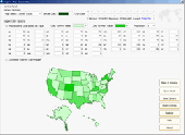
Region Map Generator is a tool to make region map with self-definition color. The original Maps in the Software are blank political region ones for different countries or areas. You can color any region with whatever color as you like. By this Software, you can easily make lively Maps. These Maps can be used as data analysis charts, teaching materials,...
Category: Business & Finance / Applications
Publisher: cciyy, License: Shareware, Price: USD $36.95, File Size: 1.3 MB
Platform: Windows
Nokia Maps 3D browser plugin is a free mapping product and service by Nokia for its mobile phones and for internet browsers. Nokia Maps includes voice guided navigation for both pedestrians and drivers for 74 countries in 46 different languages and there are Maps for over 180 countries.
See the world in high-resolution 3D. Everything from the sky to the street. Plan...
Category: Internet / Browser Accessories
Publisher: Nokia, License: Freeware, Price: USD $0.00, File Size: 9.8 MB
Platform: Windows
Freeware
Free standalone Software DataPult Desktop creates heat Maps from your data quickly and efficiently. Key features: Direct data import from MS Excel with one click. The ability to create animated Maps of data over several years. Interactive Maps and diagrams. 39 map colorings for making heat Maps. Intelligent identification of...
Category: Business & Finance / MS Office Addons
Publisher: DataPult, License: Freeware, Price: USD $0.00, File Size: 21.0 MB
Platform: Windows