Free Downloads: Street Maps States Shp
NOVA Maps provides appraisers and appraisal users with complete, high-resolution location Maps (also known as “Street Maps”) for forms and addenda in seconds. NOVA Maps even automatically places labels for subject properties and comparables.
For just pennies per map and with just a click of the mouse, users have access to the entire...
Category: Home & Education / Miscellaneous
Publisher: Day One, License: Demo, Price: USD $0.00, File Size: 5.7 MB
Platform: Windows
APRS SA does most of the functions of the original APRS(tm) with a big difference: The Maps it uses to plot the locations are Street Atlas 4.0 or 5.0 Maps. This allows great precision in locating objects and stations. This program track a moving vehicle and do it at the Street level.
Category: Home & Education / Miscellaneous
Publisher: Brent Hildebrand, KH2Z, License: Freeware, Price: USD $0.00, File Size: 2.0 MB
Platform: Windows
 Freeware
An interactive Flash USA map with all the features you need for your web site or project. This is the ideal solution for dealer Maps, real-estate listings, or visualizing state statistics. Nearly every aspect of the map is customizable. However, unlike competing products, our map is very simple to install and edit. Just upload XML and SWF files and embed.
Category: Internet / Flash Tools
Publisher: http://www.flashusamap.com/trial/flashus, License: Freeware, Price: USD $0.00, File Size: 93.8 KB
Platform: Unknown
UK Local business directory with addresses, telephone numbers and street maps.
UK Local business directory with addresses, telephone numbers and Street Maps. Including accountants, builders, car hire, computer shops, dentists, doctors, driving schools, estate agents, florists, garages, hotels, photographers, jewellers, post offices, printers, pubs solicitors, taxis and used car dealers.
Category: Desktop Enhancements / Screensavers
Publisher: Localdir, License: Freeware, Price: USD $0.00, File Size: 696.0 KB
Platform: Windows
London business directory with addresses, telephone numbers and street maps.
London business directory with addresses, telephone numbers and Street Maps. Including accountants, builders, car hire, computer shops, dentists, doctors, driving schools, estate agents, florists, garages, hotels, photographers, jewellers, post offices, printers, pubs solicitors, taxis and used car dealers.
Category: Desktop Enhancements / Screensavers
Publisher: London-Dir, License: Freeware, Price: USD $0.00, File Size: 697.0 KB
Platform: Windows
Single State Mapping Tool allows you to create Maps of individual States with Microsoft® MapPoint® 2002, 2004 or 2006. Make Maps of individual States. For various purposes, many users of Microsoft MapPoint would like to cover up neighboring States for their Maps in Microsoft MapPoint. This tool allows you to do that. Demo data file allows you to...
Category: Business & Finance
Publisher: MP2KMag and Winwaed Software Technology LLC, License: Data Only, Price: USD $75.00, File Size: 1.4 MB
Platform: Windows
Be sure to get it safely and effectively to the place you want.
Be sure to get it safely and effectively to the place you want. Whether you're following the traffic signs or instructions hastily printed from the website, it’s too easy to skip a turn or lose track of the Street where he is or needs to be. The software for trip planning Streets & Trips 2009 makes planning your next trip is simple. We also help them find their destination...
Category: Audio / Utilities & Plug-Ins
Publisher: Microsoft, License: Shareware, Price: USD $0.00, File Size: 1.2 GB
Platform: Windows
The Street Fighter legacy continues with this expanded version of Street Fighter II.
The Street Fighter legacy continues with this expanded version of Street Fighter II. Included are four new characters - Cammy, Dee Jay, Fei-Long, and T.Hawk -with new backgrounds for each. Returning fighters have also been given a make-over (both in in-game art as well as in the character portraits) and have learned new moves for the ongoing tournament.
System Requirements:...
Category: Games / Action
Publisher: Pyramid-Games, License: Freeware, Price: USD $0.00, File Size: 3.2 MB
Platform: Windows
Nokia Maps 3D browser plugin is a free mapping product and service by Nokia for its mobile phones and for internet browsers. Nokia Maps includes voice guided navigation for both pedestrians and drivers for 74 countries in 46 different languages and there are Maps for over 180 countries.
See the world in high-resolution 3D. Everything from the sky to the Street....
Category: Internet / Browser Accessories
Publisher: Nokia, License: Freeware, Price: USD $0.00, File Size: 9.8 MB
Platform: Windows
News Maps visually reflect news aggregated from numerous sources including Reuters, Wall Street Journal, NY Times, Washington Post, BBC, Digg, Reddit and many more news outlets from around the world.
The most popular stories occupy the largest rectangles while less popular stories fall into progressively smaller rectangles. You can see all the headlines and read any...
Category: Utilities / Misc. Utilities
Publisher: TimBukOne (Pty) Ltd, License: Freeware, Price: USD $0.00, File Size: 5.9 MB
Platform: Windows
UK Post Offices Directory with addresses, telephone numbers and street maps
UK Post Offices Directory with addresses, telephone numbers and Street Maps. Covering hundreds of towns within the UK.
Category: Business & Finance
Publisher: Directory of Post Offices, License: Freeware, Price: USD $0.00, File Size: 685.9 KB
Platform: Windows
Freeware
Arm Map Explorer recreates all the functionalities of Google Maps on your desktop while expanding them with new extras. Map Explorer lets you locate and view any place on the planet using dynamic interactive Maps. These Maps are draggable, which means there is no need for you to click and wait for graphics to reload each time you want to view adjacent parts of a map....
Category: Internet / Flash Tools
Publisher: ArmCode, License: Freeware, Price: USD $0.00, File Size: 5.5 MB
Platform: Windows
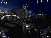
3D street racing game. Night street racing is a major attraction in big cities around the world.
3D Street racing game. Night Street racing is a major attraction in big cities around the world. The racers are legendary for their need for speed, while the cars they drive signify the perfect union of consumer-grade auto manufacturing and extreme vehicular tuning. Now you can become a night Street racer. You will take part in competitions, earning cash and winning new...
Category: Games / Simulations
Publisher: gamehitzone.com, License: Freeware, Price: USD $0.00, File Size: 34.3 MB
Platform: Windows
Freeware
Convert ESRI ShapeFiles (.Shp) geolocation data into AnyMap format to be used with AnyChart. AnyChart Flash Map Converter allows making use of a wide choice of Maps with AnyChart Flash Component, a GIS visualization system that recognizes map data in AnyMap format only. AnyChart Flash Map Converter makes it easy to visualize any geolocation data without hefty expenses associated...
Category: Web Authoring / Image Mapping Tools
Publisher: AnyChart.Com, License: Freeware, Price: USD $0.00, File Size: 1.6 MB
Platform: Windows
UK Restaurants Directory with addresses, telephone numbers and street maps. Covering hundreds of towns within the UK.
Category: Home & Education
Publisher: restaurants-dir, License: Freeware, Price: USD $0.00, File Size: 696.8 KB
Platform: Windows
UK Solicitors Directory with addresses, telephone numbers and street maps. Covering hundreds of towns within the UK.
Category: Business & Finance
Publisher: solicitors-dir, License: Freeware, Price: USD $0.00, File Size: 696.8 KB
Platform: Windows
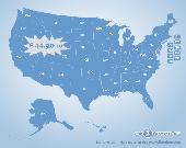
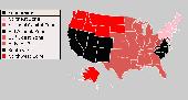
US States Flash map Silver (with FLA source)
for web sites, interactive applications, presentations, and more.
With this fully-clickable map you will be able to improve navigation and provide visitors with better and quicker access to information as well as improve the way you present the information. The map can be easily customizable. In just a few minutes you can make any...
Category: Web Authoring / Web Design Utilities
Publisher: Fla-shop.com Inc., License: Demo, Price: USD $44.90, File Size: 140.0 KB
Platform: Windows
Shareware
MPSuperShape is a shape manipulation tool for Microsoft MapPoint. MPSuperShape can be used to combine multiple shapes into one large shape, find the intersections (overlaps) between shapes, find boundary shapes around groups of pushpins, simplify shapes, delete multiple shapes, change shape colors, import/export shape files, and to create web pages. Import shape options include ESRI Shape...
Category: Business & Finance / Business Finance
Publisher: Winwaed Software Technology LLC, License: Shareware, Price: USD $75.00, File Size: 13.6 MB
Platform: Windows
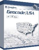
Map Suite Geocode USA is a powerful and feature-rich .NET geocoding engine that comes complete with a highly optimized dataset encompassing the entire United States. Map Suite Geocode USA features a fast, user-friendly .NET interface that enables C# and VB.NET software developers to take a United States address and quickly find its geographical location. In addition to geocoding,...
Category: Software Development
Publisher: ThinkGeo LLC, License: Commercial, Price: USD $2394.00, File Size: 341.1 KB
Platform: Windows
Anychart is a flexible Macromedia Flash based-solution, which allows you to easily display any sort of data dealing with geographical locations. It contains United States Maps with Counties, World Map, etc. XML data file and a set of customizable options make AnyChart Maps a universal solution for web developers. AnyChart allows you to create superb, compact, interactive...
Category: Software Development
Publisher: AnyChart.Com, License: Shareware, Price: USD $199.00, File Size: 2.8 MB
Platform: Windows, Mac, Linux, Palm,

Commercial realtors require accurate and reliable tools to publish available properties online and show them on the website (specifying region, county, state, and city). We have created a unique Interactive Real Estate Map with all USA States and counties on it for real estate business. USA Real Estate Map is a unique and amazing vector-based tool that is very simple to use. We...
Category: Internet
Publisher: USFlashMap.com, License: Shareware, Price: USD $399.00, File Size: 3.9 MB
Platform: Windows, Mac, Linux, Unix, MS-DOS, AS/400, OS/2
For many countries Street coordinates are present with coverage degrees upto 100 percent. The geo data offered here are in high-precision quality and are present in different coordinate and reference systems. Street coordinates or also called Street section coordinates are meaning the summary of several postal house addresses to an averaged position on Street or...
Category: Business & Finance
Publisher: C. Killet Software Ing.-GbR, License: Demo, Price: USD $625.00, File Size: 66.6 KB
Platform: Unknown

For the area of the Federal Republic of Germany more than 2,7 million Street coordinates with a coverage of 100% are available. The geo data offered here are in high-precision quality and are present in different coordinate and reference systems. Street coordinates or also called Street section coordinates are meaning the summary of several postal house addresses to an...
Category: Business & Finance
Publisher: C. Killet Software Ing.-GbR, License: Demo, Price: USD $625.00, File Size: 68.4 KB
Platform: Unknown
Capture the yellow pages in Europe, United States and Canada.
Capture the yellow pages in Europe, United States and Canada.
Features:
-Names of companies
-Complete Mailing Addresses --(Street - Postal Code - City)
-Phone Numbers --(Fixed - Mobile - With special tarification...)
-Fax numbers
-Email Addresses
-Business Websites
-Business activities
Category: Utilities / System Utilities
Publisher: RJCapture, License: Shareware, Price: USD $65.99, File Size: 481.9 KB
Platform: Windows