Free Downloads: Virtual Gps Download Free
 Shareware
If you want to change your Gps location while playing AR games due to bad weather, you could achieve this with Aiseesoft AnyCoord and you do not need to walk around. Importing or exporting a GPX file are also supported. Key functions: 1. Set Virtual location for iDevices Aiseesoft AnyCoord enables you to change the actual Gps location of your iDevices to a...
Category: Utilities / System Utilities
Publisher: Aiseesoft Studio, License: Shareware, Price: USD $9.95, File Size: 1.9 MB
Platform: Windows
Portable GPS Navigation toolbar for Internet Explorer.
Portable Gps Navigation toolbar for Internet Explorer. Find portable Gps units for your car, truck or minvan from top name brands including Tom Tom, Magellan and Garmin. Discover the world of eBay and shop for portable Gps navigation systems directly from your browser toolbar.
Category: Internet / Browsers
Publisher: Portable GPS Navigation System, License: Freeware, Price: USD $0.00, File Size: 1.1 MB
Platform: Windows

Gps/J is a console for all Bluetooth-enabled Gps receivers (now with 20000 European towns and cities!), a mobile navigation tool for cellular phone owners and the most affordable and convenient way to use location services.
It is a J2ME application for JSR82-compliant devices, which means "devices with a programmable Bluetooth interface".
Saying...
Category: Home & Education / Miscellaneous
Publisher: GPS/J Project, License: Demo, Price: USD $0.00, File Size: 281.0 KB
Platform: Windows
Gps Tracker Data Logger acts as the server and allows you to collect data from an unlimited number of various Gps trackers simultaneously. The obtained data is processed, uniformed and written to a log file or a database. Also, the program has a set of interfaces so other applications can get data in real time.
Gps Tracker Data Logger can convert data into other...
Category: Internet / Misc. Servers
Publisher: AGG Software, License: Shareware, Price: USD $80.83, File Size: 11.8 MB
Platform: Windows
GPSCommunicator is a FREE utility to visually represent NMEA GPS position data in realtime.
GPSCommunicator is a Free utility to visually represent NMEA Gps position data in realtime. It works with NMEA 0183 Gps receivers connected via a serial port. GPSCommunicator has the following features:
- Vessel position display over moving map.
- User selectable maps.
- Create and save Waypoints.
- Graphical Gps data display
- .NET...
Category: Internet / Misc. Plugins
Publisher: Panazzolo.Com, License: Freeware, Price: USD $0.00, File Size: 772.5 KB
Platform: Windows
GPS Tuner was first launched in 2003.
Gps Tuner was first launched in 2003. Success followed introduction shortly. Over the years it became a best-selling favourite Gps software among off-roaders as a reliable, versatile feature-packed application suiting the needs of outdoor enthusiasts and professional off-road users alike. After five years of continuous development of previous Gps Tuner versions Gps...
Category: Web Authoring / Web Design Utilities
Publisher: GPS Tuner Ltd., License: Freeware, Price: USD $0.00, File Size: 4.5 MB
Platform: Windows
Serial Splitter Mobile by Eltima for Windows Mobile 2003/2005 operating systems is a new generation of professional system utilities for mobile devices. This is the software for splitting real serial ports into Virtual ones. It can be useful if you need several applications to work with the same serial port on your mobile device simultaneously. Finally, one program works with one...
Category: Utilities
Publisher: ELTIMA Software GmbH, License: Shareware, Price: USD $49.95, File Size: 147.0 KB
Platform: Unknown
VSPD Mobile Phone Edition is a brand-new generation of already popular driver for mobile devices released by Eltima more than a year ago. Now we bring a totally new level of serial emulation for SmartPhones based on Windows Mobile platform! VSPD Mobile Phone Edition is capable of creating up to 20 pure Virtual serial ports in your mobile system, this results in up to 10 Virtual...
Category: Software Development
Publisher: ELTIMA Software GmbH, License: Shareware, Price: USD $49.95, File Size: 116.0 KB
Platform: Unknown

OziPhotoTool combines the technology of a Gps receiver and a digital camera to automatically keep a record of where digital photos were taken. It is designed to be used in conjunction with OziExplorer. Most digital cameras have EXIF metadata stored as part of the photo. This includes is the date and time the photo was taken. Many Gps units have 'tracklogs'. The Gps keeps a...
Category: Utilities
Publisher: OziPhotoTool, License: Shareware, Price: USD $25.00, File Size: 14.3 MB
Platform: Windows
Demo
ZylGPSReceiver is a Delphi/CBuilder component that communicates with a serial Gps receiver. It returns latitude, longitude, altitude, speed, heading and many other parameters of the position. This component works with any NMEA compatible receiver connected to one of the serial ports. You can use it also with USB and Bloototh devices, because these devices usually have a driver...
Category: Software Development / Components: Delphi
Publisher: Zyl Soft, License: Demo, Price: USD $129.99, File Size: 1.7 MB
Platform: Windows
The Gps Detector software is used to update the Gps detector's database , updating maps , routes and camera locations . The device itself is based on pre-installed Gps coordinates, the device can indicate various road hazards like: Fixed cameras, Red light speed cameras and bus lane cameras, Usual speed measurement places and dangerous zones.
Category: Business & Finance / Business Finance
Publisher: Euro Noliker Kft., License: Freeware, Price: USD $0.00, File Size: 5.5 MB
Platform: Windows
CompeGPS is an essential software to make the most of your Gps. With this PC software you will be able to Download a wide variety of cartography from the internet and also analyse your routes. This software has been specially designed for Free flight and motor flight pilots they use Gps and likes to create and accomplish their own routes and then later on...
Category: Home & Education
Publisher: CompeGPS TEAM S.L., License: Shareware, Price: USD $106.00, File Size: 14.9 MB
Platform: Windows
GPS-CCD:is a novel computational program for the
Prediction of Calpain Cleavage Sites.
Gps-CCD:is a novel computational program for the
Prediction of Calpain Cleavage Sites.
The online service and local packages of Gps-CCD 1.0 were
implemented in JAVA/. For the online service, we tested the Gps-CCD1.0 on a variety of internet browsers, including Internet Explorer 6.0, Netscape Browser 8.1.3 and Firefox 2 under the Windows XPOperating System...
Category: Web Authoring / JavaScript
Publisher: The CUCKOO Workgroup, License: Freeware, Price: USD $0.00, File Size: 19.2 MB
Platform: Windows
Shareware
Are you looking for a strong location changer? Just try imyPass iPhone Location Changer. It wont let you down. With it, you can modify and set fake location for iOS devices conveniently. Key Functions: 1. Change Gps location. Dont want others to know your actual location and expose yourself? imyPass iPhone Location Changer can do you a favor. This powerful product can be a...
Category: Audio / Utilities & Plug-Ins
Publisher: imyPass Studio, License: Shareware, Price: USD $9.90, File Size: 2.2 MB
Platform: Windows
ThinkVantage Gps (Global Positioning System) receives signals from the Gps satellites and determines the location of your ThinkPad. This program is easy to install and easy to manipulate.
This package installs the software (Gps driver) to enable the following devices:
- Ericsson F3507g
- Ericsson F3607gw
- Ericsson F5521gw
-...
Category: Utilities / System Utilities
Publisher: Lenovo, License: Freeware, Price: USD $0.00, File Size: 20.6 MB
Platform: Windows
Have a Gps and a laptop? Use this to find your way. Make patterns or a trail to share with others. When the application starts, you may pick your area of operations - be it North America, South America, Europe and Asia, or Australia. Your quadrant is determined by where you are in relation to the Equator and the Prime Meridian. Tracking of your position is automatically enabled when the...
Category: Home & Education / Miscellaneous
Publisher: LogicAll Solutions, LLC, License: Freeware, Price: USD $0.00, File Size: 4.6 MB
Platform: Windows
Shareware
ZylGPSReceiverAX is an an award-winning ActiveX control that communicates with a serial Gps receiver. It returns latitude, longitude, altitude, speed, heading and many other parameters of the position. This control works with any NMEA compatible receiver connected to one of the serial ports. You can use it also with USB devices, because these devices usually have a driver that...
Category: Software Development / ActiveX
Publisher: Zyl Soft, License: Shareware, Price: USD $99.99, File Size: 863.4 KB
Platform: Windows
Freeware
With this tool you can add Gps coordinates to vCards - elektronic business cards - that you have previously exported from e. g. Microsoft Outlook. Therefore the tool uses the address data contained within the vCards and adds the exact Gps position on that basis to the vCard. This way you can use these vCards for example in compatible car navigation systems. Among others...
Category: Home & Education / Home Inventory
Publisher: AB-Tools.com, License: Freeware, Price: USD $0.00, File Size: 1.9 MB
Platform: Windows
GPSCAD Transfer is an application for transferring points between a gps device and autocad.
GPSCAD Transfer is an application for transferring points between a Gps device and autocad. The present version works with a Magellan Gps device, but the next release will also work with a Garmin Gps device. It allows you to convert latitude and longitude to utm zone nad 83 in either the US or in metric measurement system.
Category: Multimedia & Design / Image Editing
Publisher: Timberwolf Software Solutions, LLC, License: Shareware, Price: USD $0.00, File Size: 2.6 MB
Platform: Windows
GPS Send Map is a Windows interface program which uses (sendmap.
Gps Send Map is a Windows interface program which uses (sendmap.exe) to load the IMG maps to the Gps.This program works well and setup is easy, although there seams to be minor issues in some windows OS.The Gps acted as usual and my maps appeared on the screen as usual. NICE.
Category: Security & Privacy / Other
Publisher: DougsBrat, License: Freeware, Price: USD $0.00, File Size: 1.5 MB
Platform: Windows
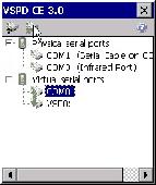
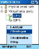
Virtual Serial Ports Driver CE creates up to 20 pure Virtual serial ports in your mobile system, this results in up to 10 Virtual serial ports pairs. Each pair has 2 ports that are virtually connected to each other. For other applications, Virtual serial ports will be seen exactly as two real serial ports connected via Virtual null-modem cable. You can select...
Category: Software Development
Publisher: ELTIMA Software GmbH, License: Shareware, Price: USD $49.95, File Size: 432.0 KB
Platform: Windows
Track-Album is a paragliding/hanggliding software - flight log for pilots, and logbook for cyclists/skiers, it is also Gps software - easy to use, sufficient for most needs, allows you to Download Gps tracks and view them in 3D in Google Earth.Rich statistics is specialy usefull for paragliding/hanggliding pilots. It is calculated instantly by entries in log book that...
Category: Home & Education / Miscellaneous
Publisher: Track-Album, License: Shareware, Price: USD $39.00, File Size: 2.0 MB
Platform: Windows
Map of Africa is one of the many maps created for GPS TrackMaker.
Map of Africa is one of the many maps created for Gps TrackMaker. You are able to Download the installation package from the TrackMaker website. In order to preview the contents of this package, you need to install Gps TrackMaker.
Using the above mentioned application, you will be able to see the Map of Africa. Just click on the "Open Temporary...
Category: Home & Education / Miscellaneous
Publisher: Geo Studio Technology, License: Freeware, Price: USD $0.00, File Size: 18.3 MB
Platform: Windows
Kinomap Gps File Fixer allows you to process some treatments on Gps file:
- convert almost any Gps file to standard NMEA 0183, compatible with Kinomap
- fill the gaps between points when your file is not 1Hertz: the extra point will be recreated by interpolation
- cut a long file in which there are loops of data (example: race) in several parts
Category: Home & Education / Miscellaneous
Publisher: ExcelLance, License: Freeware, Price: USD $0.00, File Size: 19.6 MB
Platform: Windows
Shareware
Gps Mapping Software for Windows, Loading topographic maps, realtime navigation, track recording, manage Gps devices and more. The software can be used with various map formats including: GeoTiff, BSB Nautical Charts, AutoCad DXF files, ESRI Shapefiles. Using calibration you can also use scanned or downloaded JPG, BMP, GIF, PNG and TIF maps. The software can be used for survey,...
Category: Home & Education / Science
Publisher: Eye4Software B.V., License: Shareware, Price: USD $149.00, EUR99, File Size: 11.1 MB
Platform: Windows