Free Downloads: Utm
For many countries street coordinates are present with coverage degrees upto 100 percent. The geo data offered here are in high-precision quality and are present in different coordinate and reference systems. Street coordinates or also called street section coordinates are meaning the summary of several postal house addresses to an averaged position on street or street section basis. The street...
Category: Business & Finance
Publisher: C. Killet Software Ing.-GbR, License: Demo, Price: USD $625.00, File Size: 66.6 KB
Platform: Unknown
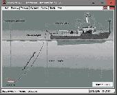
DRAGSENS Geo Software is used for the exact position estimation of a towed body, sensor, camera, array or net, dragged behind a ship, aircraft or vehicle. The software allows a real-time estimation of the position of a dragged sensor based on the location of a GPS-receiver. The sensor thereby can be dragged underwater, at water or earth surface or be airborne. The software calculates the...
Category: Home & Education / Science
Publisher: Killet Software Ing.-GbR, License: Shareware, Price: USD $145.00, EUR130, File Size: 2.0 MB
Platform: Windows

Importation/Exportation: Import/export trails to gpx file. Unlimited number of trails, and TrackPoints. Export to gpx, Excel, PDF, XPS and KML/KMZ. Data table: Very flexible data table that allows sorting by columns, with inheritance of data, attributes, etc. Presentation on map: View on map in accordance with the active trail, which comes from providers of maps, as in 'Satellite' mode...
Category: Home & Education / Miscellaneous
Publisher: Aplicaciones Topográficas S.L., License: Freeware, Price: USD $0.00, File Size: 27.0 MB
Platform: Windows
Engenious Systems is making available a GIS based application that will enable users working in Washington State to visually select any location to retrieve rainfall precipitations. Washington State Isopluvial Selector tracks mouse location by Utm coordinates or Longitude and Latitude.
Category: Software Development / Misc. Programming
Publisher: Engenious Systems, Inc., License: Shareware, Price: USD $50.00, File Size: 523.9 KB
Platform: Windows
SHPTRANS is a fast, high-precision NTv2 datum transformation and projection utility which reads and writes shapefiles. SHPTRANS is intended to complement, not replace, existing projection tools such as those within ArcView GIS 3.x and ArcGIS 8.x.SHPTRANS supports the following projections: Utm (tested for North America; intended to support all 60 zones in both hemispheres), MTM 3-degree...
Category: Utilities / Misc. Utilities
Publisher: Bruce Dodson, License: Shareware, Price: USD $0.00, File Size: 335.0 KB
Platform: Windows
TransDEM Trainz Edition is a dedicated version of TransDEM, enhanced with specific export functionality for Auran/N3V Trainz Simulator 2010, Trainz Simulator 2009, Trainz Railroad Simulator 2006 and 2004. This additional export functionality enables the user to create Trainz route maps in TransDEM, using geo data currently loaded. Direct creation of all files which make up a Trainz route map....
Category: Multimedia & Design / Image Editing
Publisher: Roland Ziegler, License: Freeware, Price: USD $0.00, File Size: 981.3 KB
Platform: Windows
Nebero, the latest release of Cyberix, is a complete Gateway Internet Protection Suite, that comes with integrated solutions like, Stateful Firewall, Asynchronous Bandwidth Management, Single Sign on with Active Directory (AD), robust Intrusion Detection System (IDS) as well as Intrusion Prevention System (IPS), 256-bit SSL Virtual Private Networking with Site-to-Site VPN capabilities, Gateway...
Category: Internet / Misc. Plugins
Publisher: NEBERO SYSTEMS Pvt, License: Demo, Price: USD $0.00, File Size: 12.4 MB
Platform: Windows
PHOTOMOD GeoCalculator is the software for points coordinates transformation, included in the PHOTOMOD system, as well as a stand-alone free application.
Its installation package includes databases of reference systems used in the world and in Russia (approximately 1500 reference systems). User can also add reference systems on his own by specifying:
-units (coefficient for...
Category: Business & Finance / Applications
Publisher: Racurs, License: Freeware, Price: USD $0.00, File Size: 7.6 MB
Platform: Windows
GeoDataSource Cities Database Gold Edition contains 2.9+ million entries with city names in original language and English, feature type classifications, country names in FIPS and ISO, regions, sub-regions, state or First-Order Administrative Division, county or Second-Order Administrative Division, longitude and latitude in degree and decimal, Univeral Transverse Mercator coordinate grid and...
Category: Security & Privacy / Other
Publisher: GeoDataSource.com, License: Data Only, Price: USD $1049.95, File Size: 160.3 KB
Platform: Windows, Mac, Linux, Palm,
 Shareware
Toolkit to add GPS functionality to your software and scripts (GPS SDK). All NMEA0183 protocol versions are supported and can be filtered by NMEA sentence type and talker ID. Information on GPS status can also be retrieved: GPS fix quality, satellites used in fix, satellites in view, satellite azimuth, elevation and signal strengths. The toolkit also offers functionality to perform map grid...
Category: Software Development / ActiveX
Publisher: Eye4Software B.V., License: Shareware, Price: USD $150.81, File Size: 1.6 MB
Platform: Windows
Shareware
Java toolkit to add coordinate conversion functionality to your Java applications and applets. The toolkit offers functionality to perform map grid and datum transformations: latitude and longitude can be converted to various map grids, like Transverse Mercator (TM), Oblique Mercator, Mercator, Oblique Stereographic, Polar Stereographic, Cassini, Albers Equal Area Conal, Gauss Kruger or...
Category: Software Development / Components & Libraries
Publisher: Eye4Software B.V., License: Shareware, Price: USD $199.00, EUR179, File Size: 155.5 KB
Platform: Unknown
Shareware
TOPOWIN is a state-wide register of the German Topographic Cartographies, the German Basic Cartography and of localities with geo references in different coordinate systems. It is also a topographic information system. In the division of planning and execution of economical and scientific projects frequently topographic documents are used. The program TOPOWIN makes information available of the...
Category: Home & Education / Miscellaneous
Publisher: Killet GeoSoftware Ing.-GbR, License: Shareware, Price: USD $125.00, EUR110, File Size: 4.5 MB
Platform: Windows
For many countries house coordinates are present with coverage degrees upto 100 percent.
For many countries house coordinates are present with coverage degrees upto 100 percent. The geo data offered here are in high-precision quality and are present in different coordinate and reference systems. House Coordinates or also called Geo Coded Building Addresses are meaning the connection between the postal addresses of buildings or building complexes and their accurate positions in the...
Category: Business & Finance / Database Management
Publisher: C. Killet Software Ing.-GbR, License: Demo, Price: USD $1420.00, File Size: 234.0 KB
Platform: Windows
SEVENPAR is a tool for the calculation of highly exact transformation parameters for the Spatial Helmert and Molodensky Transformation, which make possible precise coordinate transformations from one reference system into another. The determined transformation parameters can be entered directly into suitable transformation software, e.g. TRANSDAT Coordinate Transformations, or into the...
Category: Home & Education / Science
Publisher: Killet GeoSoftware Ing.-GbR, License: Shareware, Price: USD $285.00, EUR240, File Size: 7.6 MB
Platform: Windows
ORTWIN is a program for the state-wide inquiry of the localities, postal codes and telephone selections in Germany. It finds postal zip codes, telephone pre selections, coordinates and ground level elevations. The program determines municipal codes, local center points, car license codes, topographic maps, Unlocodes and much more. It arranges localities hierarchically into the structures...
Category: Business & Finance / Sales & Marketing Tools
Publisher: Killet GeoSoftware Ing.-GbR, License: Shareware, Price: USD $120.00, EUR110, File Size: 4.8 MB
Platform: Windows
In the Dynamic Link Library GeoDLL geodesic functions like coordinate transformation, datum changes, meridian strip changes, user defined coordinate and reference systems, distance calculation, maps functions, Digital Elevation Models and more geodesic functions are contained to bind them into own applications. WINDOWS operating system allows building of function libraries intended for use by...
Category: Software Development
Publisher: Killet Softwareentwicklung GbR, License: Shareware, Price: USD $290.00, File Size: 999.9 KB
Platform: Windows
Shareware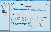
Traffic Inspector is an all-in-one Windows-based software solution for network security, web access control and traffic analysis. The solution is equally suitable for small and medium-sized businesses. Traffic Inspector gives you a plethora of tools needed to protect your network. Internet access control. Access to Internet resources is granted to authenticated users. Logon hours,...
Category: Internet / Anti-Spam
Publisher: SMART-SOFT, License: Shareware, Price: USD $194.00, EUR149, File Size: 32.5 MB
Platform: Windows

TRANSDATpro can prove a helpful tool for professionals, providing them with the possibility to perform coordinate transformations fast and easy by use of the coordinate reference systems of their choice. TRANSDATpro performs Coordinate Transformations fast and with high accuracy. The coordinate conversion software supports worldwide thousands of Coordinate Systems, geodetic Reference Systems...
Category: Home & Education / Science
Publisher: Killet GeoSoftware Ing.-GbR, License: Shareware, Price: USD $270.00, EUR240, File Size: 5.3 MB
Platform: Windows

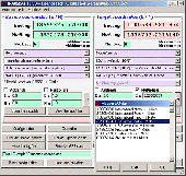
TRANSDAT geosoftware executes coordinate transformations and geodetic datum shifts between many coordinate and reference systems of America, Australasia, Europe, Germany special and world-wide, with high precision and high speed: 1.The current and historical coordinate and reference systems of all countries of the European Union (EU) including the eastern extensions and the systems of non-EU...
Category: Home & Education / Science
Publisher: Killet Software Ing.-GbR, License: Shareware, Price: USD $170.00, EUR160, File Size: 4.4 MB
Platform: Windows
GeoDataSource Structural Features Database Gold Edition contains structural feature names in original language and English, feature type classifications, country names in FIPS and ISO, regions and sub-regions. Database in text format suitable for applications requiring a complete list of city names. It is a subset of the GeoDataSource Structural Features Database Gold Editions. Please visit...
Category: Business & Finance
Publisher: GeoDataSource.com, License: Data Only, Price: USD $1099.95, File Size: 73.1 KB
Platform: Windows, Mac, Linux, Palm,